Nam Fa

Showing posts with label Nam Fa. Show all posts
The area east of the Mekong, however, was soon wrenched back from Siam by the French Nam Fa. the Communist Pathet Lao took control of Vientiane and ended a six-century-old monarchy. Initial closer ties to Vietnam and socialization were replaced with a gradual return to private enterprise, an easing of foreign investment laws, and admission into ASEAN in 1997.

Wildside Trip on the Nam Fa (from quite a while ago)


Tiger Tracking on the Nam Pha from Frank Wolf on Vimeo.

This video is of a white water rafting trip down the Nam Fa in the late nineties or the early part of the last decade.

It looks like the video was made by someone who makes adventure videos with no connection to the actual trip. The trip was organised by Wildside adventures run by Michael O'Shea also known as the guy that kayaked the entire length of the Mekong with lots of good stories from half drowning in Tibet of Yunnan province, I read his account of the trip online a long time ago.

This is kind of a run on post, I'm hoping that someone who was in the area at the time will post a long and if they want anonymous or not comment about the whole thing and I'll erase this half conjecture collection of run on sentences with some factual information. Hint hint you know who you are.

Looks like most of the time was spent above the junction of the Nam Hee where the river is most turbulent and it probably took them the most time to get down. Assuming the Kahmu village was up close to Vieng Phuka somewhere. Don't know about the Akha village, a just moved Jakune Mai? The camera traps that used film were a give away. Don't know when digital came out but it's an indicator.

Nam Fa means Sky River


I have no doubt as to where I am when I wake up to the sound of the saht hitting the koak-tam-kao. The foot powered pestle falling into the large mortar carved from a log is such a low solid sound it reverberates through the hard packed earth and up the posts the house is built on and into beams supporting the floor and the sleeping platform I lie on.

Usually I wake up when the eldest wife starts the fire. Today the sun is fully up and the wife of the eldest son is dehusking the rice under the house. There’s a slight creek as one end of the long pole attached to the saht is pushed down with the foot, then a hesitation as the saht at the other end tops it’s arc then that moment that hangs in time as saht falls through the air and hits the coak.

The chickens are eager to get any fallen grains, the husks will be collected to be mixed with the boiled hearts of banana trees to feed the pigs, and the family has rice for one more day of the year, one of many years, in many generations, of the people called Akha.
Koak tam kao, and in her hand the cotton she is twisting into thread, notice the rice bag that is actually an old fertilizer bag bought from town, it still has the markings 18-20-0 representing how much NPK.

I rub the sleep from my eyes, grab my camera and duck underneath the house to take a photo. I know at the time it’s just a cornball tourist photo. Gotta have a picture of the foot powered saht. I’m accompanied by a couple kids and a dog, the woman is spinning cotton fibers into thread at the same time as she pushes the saht with her foot.

I saw a video shot in Vientiane by some sort of cultural preservation arm of the government, they were taking kids to see a foot powered sat tam kao. Kids in the capital can now grow up never having seen rice de husked except by machine. Gone the way of the water buffalo I guess.


This post is part of a series of posts about a long walk I did mostly in Muang Long district of Luang Namtha Province Laos in the winter of 08/09. Below are the links to the other posts.
Long Time Traveler Muang Long
One Day Treks in the Vicinity of Muang Long
Lahu NIght Out
The Trail To Nambo
Hmong House
Further Into the Forest
Ban Nam Hee
Lost in Laos


On the left the Naiban of ban Huay Poong, on the right the local guide from Ban Nam Hee

Inside breakfast is busy with lots of people. We had rice and a jeao made of toasted peanuts, hot peppers, pig oil, and enough salt to cause stroke. The headman pulled an SKS out of the roof above where I’d been sleeping, opened the magazine dropping six cartridges onto the blankets, worked the action to extract the one left in the chamber, and handed it over to one of the guys that had come to breakfast.
Young hunter with SKS

Tui translated. The young men had chased a large boar the day before. The wounded pig was too tough and they hadn’t been able to kill the it. One of the dogs was hurt so badly it might well die. I could picture scene in my head, young guys running around in the bushes, dogs whirling about, pig snorting and screaming, dogs barking and biting, thick brush and trees, muffled explosion of black powder muskets with lots of smoke that lingers in the slow air of the deep forest.

The hunter was borrowing the center fire rifle to finish the job today. Cartridges are expensive, probably around a dollar a piece, the headman is fine loaning out the rifle but not the ammo. The rifle is called the same thing in Laos as in the US except using mangled french consonants that come out something like Sik Kuh Say. It’s a soviet block semi auto, uses the same rounds as the AK, might well be half a century old.

A new local guide is hired. Tui, and the guides discuss the route, our old guide will return to his village and a new one will take us to Jakune Mai. I was beginning to lose track of how long we’d been out, it had only been three days and nights. This house and other houses and other cook fires in other villages in other trips seem to meld into the fires of the juggies up on the Greys river and on into the Androscoggin of my young teens.

The headman told of his difficulty kicking his addiction to opium, and his re acceptance by the people of the village. I listen with ambivalence. Opium is as much a part of their culture as the saht to dehusk the rice, it’s up to them to refrain from liking it too much.  There’s more talk, of the division of the village, of the route to Jakune, of the other villages of the area.

Soon enough we were walking again. Walking was becoming the thing we do. First the local guide I called uncle, then me, and then Tui. The blister on the ball of my left foot had been hurting for a couple hours each morning, either the feeling would go away or I would stop noticing.

The walking goes easy, down hill but not steep.
Not a the biggest by any means but that root flare is greater than two meters. This just happened to be where we took a break. Purple back pack on left of photo

By late morning were in the very large trees of the Nam Fa Valley. (nam means water or in this case river, fa is sky, so “sky river”. I’m used to very large trees and uncut forests, but the soil at the bottom of the valley is so rich the trees grow very high and the trunks are very large, some of the largest trees I’ve ever seen anywhere. The roots flare out widely to support such weight. What light filters through seems green.

I read a while ago on one of those online forums for scientific NGO workers that a Malaysian lumber company would like to build a hydro dam on the Nam Fa. The fact that the company up to this time only deals in wood is enough to make you wonder. The valley is a long long way from anyone that needs large amounts of electricity.

We took a break at a trail junction. To our left was the path to Mongla an unknown number of kilometers downstream on the south bank of the river. At least here was a route to somewhere I’d been before. I remember Mongla as it was when I left it over two years before, the morning mists so thick and heavy everything was dripping, the soft spoken Naiban and his very pretty young second wife not yet with a child.

I put on my flip flops to protect me from stones bruising my feet and used a couple of poles to steady myself. The Nam Fa was as I remember, knee to mid thigh deep, very fast, and fifty meters wide. In this land of deep forest the river is open to the sky and reflects blue. There is the musty wet smell of a big river.
Nam Fa means Sky River

From the water marks on the bank it looks as if the common high water in the wet season is four feet deeper. With six feet of water coursing through, the river would be impossible to cross for many months of the year. In a place where all travel is by foot an impassable river would create a long barrier.

For a while we just look at the river. The Nam Fa is only navigable in portions, it provides no access as a transportation route. The place where it enters the Mekong is difficult to see, it joins in the middle of a set of rapids, the sandbar pushed up by the confluence is high. I have looked for the entrance a couple of times, it hides itself well. The Fa joins the Mekong just below Xiengkok, someone had to point to it for me to see.

Across the river we walk to a village high above the flood plain. I’m not real happy. We still aren’t close to Jakune, the village is another one neither Tui nor I have ever heard of. It’s called Ban Jungah Mai, the Naiban is only 22yrs old, and he also is named Tui. I don’t know which is more unusual that a small village had such a young headman or that an Akha guy had a Lao name.

I headed under the shade of the house and watched a woman weaving while Tui made arrangements for us to continue on towards Jakune. It’s always a problem with a guide, they want to return to their village, the further they walked the more they want to ditch you and head back.
Weaving Ban Jungah Mai

We headed back downhill towards the river but at right angles to the direction we’d come up. After an hour in the mid afternoon hot sun we reach a tributary just before if joins the main river and miraculously two boats.

It’s difficult to describe how startling it was to see boats. The valley we were in is remote in large part due to the impassable rapids up and downstream. The peoples are Akha, Hmong, Lahu, yet here were some Lu with boats.

The Lu are a type of “Tai” peoples, sharing a similar language to the Thai, Lao, Thai Nua, Dai, etc., and also sharing a similar Teravada Bhudism, similar writing systems, etc. These young guys were River Lu. The kind of Lu who live along rivers and are specialists with boats and fishing. Never before had any Lu lived along the middle portions of the Nam Fa.
Boat on the middle portion of the Nam Fa

Our new guide and a few of his friends and their wives and children had hiked in carrying their tools and built the boats on site where they used them in the few miles with navigable rapids. They also built a water wheel to power their sat tam kao to relieve the women of one daily chore.

Very quickly the boats are down the four kilometers to the landing for the trail to Jakune Mai. Tui and our new guide know each other. Tui used to teach high school and the guide was one of his students.

As we walk up the hill and Tui and the guide talk, I notice that the long muzzle loader our guide is casually carrying over his shoulder is pointed straight backwards and into my face. Interrupting I start to ask Tui if there isn’t some sort of safer walking arrangement and with a couple quick words they put me in the front of our little band. Tui explains the locals have never had any training.  I’d guess all that would be needed would be for the hammer to catch on a twig. Call my a nervous Nellie if you will.
Local Lu Guide

We head uphill. The grade is fairly steep and continuous. Afternoon turns to dusk and the guide leaves us to jog back to the river while there is light. The trail is well used and obvious. Dusk lingers in twilight then it’s dark. I turn on my headlamp and Tui switches on his flashlight which flickers for a while before dying. I figure now is as good a time as any to start talking about snakes.

I don’t like walking at nights, I much prefer sitting, or sleeping. We got to Jakune Mai before it was very late, I doubt it was much past seven or eight. Walked right on through the village without people noticing much, there are no lights, we’re just a couple more people wandering around in the dark. Dogs didn’t even bark. Maybe we smelled like everyone else.

Despite the dark, finding our way to Law Pao’s house was obvious, the village lies on a grade and the house is situated at a certain angle. For the first time in a few days I was in a place I’d been before.
Village Swing in the Morning Fog

Lost in Laos (and first white guy)

We had lost the trail a long time ago and I for one had no idea where we were going and neither did my guide. If the local guide had a clue he wasn’t sharing, so that’s two out of three at least.

We weren’t lost lost, none of us had lost our sense of direction or anything. The road from Thailand was still over there, the Mekong somewhere in front and China way in back. I’ve been getting lost since I was eight or nine in woods not so different than these. Things have been worse in this life, at least we were standing on solid ground, it was warm enough, we had water.
Crossing the Nam Fa

It was certainly no where near as bad as I’d had it a couple years before not thirty kilometers from where we now wandered. At that time we’d ended up just heading in the direction of a road. This time we were a lot further from a road, but we were not too far from the village we’d slept in.

My guide Tui who is actually the director of Tourism in the prefecture wasn’t too pleased. He figured I’d be perturbed. I wasn’t, other than the inconvenience I was ok. Long walks into untraveled areas with inexperienced guides often end up with some wrong turns along the way. Maybe I should start at the beginning.

For anyone wishing to read about the walks leading up to this day, below are links to what are the preceding stories about this walk.
Long Time Traveler Muang Long
One Day Trecks In The Vacinity of Muang Long
Lahu Night Out
The Trail To Nambo
Hmong House
Further Into The Forest
Ban Nam Hee

We’d gotten a slow start leaving Ban Nam Hee. Tui went and adjusted the antenna for the kids watching TV, no one in the village knew how to adjust the satellite TV. The school master awoke blinking in the sunlight, last night’s drinking session had taken it’s toll. I guess the teacher was a little out of control, they needed a new one. School is kind of important to a village with 100% illiteracy. Not one single person could read or write other than the schoolmaster the government had sent.

By the time we moseyed down and crossed the river it was mid day. The river was the Nam Fa, we crossed it just below the junction of the Nam Hee. There was a raft on the other side. Our local guide shed his clothes, swam over, and poled across to get us. We didn’t even take our shoes off so to save time. Photo above

Once across the river we followed the main trail for only a short way before diverging on a less traveled path. The fainter trail headed steeply uphill until we left the immediate river valley. As it gained elevation the trail became more difficult to see.

Sometimes trails get grown over due to a lack of use. That wasn’t the case here, this trail was progressively more faint. Tui remarked how when locals walk off trail in the woods they often break small seedlings pointing the broken top in the direction of travel. Then he did just that, and so did I feeling slightly silly. Eventually we were just walking in the woods. Once in a while Tui or the local guide would hack at a creeper with their long knives.

When the understory became thicker and the hill steeper slowing us down to a very slow pace, I asked Tui if we just maybe ought to call it a day. Go back to the village we knew and start anew the next day. Neither the local guide nor Tui wanted anything to do with that, big loss of face on returning to the village.

I don’t know how we ended up taking the route we had, I’d been more or less passively tagging along, I guess it was as much my fault as anyone else. I was the oldest, and though these were the woods and hills of our local guide I should have quizzed him more about where we were headed before starting out. To tell the truth I didn’t have three words in common with the young fellow. Tui was communicating using Lu I assumed, but I think our local guide’s command of the Lu language was extremely limited. The chance of him speaking any Lao or even being able to use the words in common between Lu and Lao was about zero. Heck even young American guys his age usually speak using grunts and snorts.

After discussion our local guide changed direction almost 180 degrees. Instead of heading straight back the way we’d come he was cutting sidehill towards the east.

We slid  down a hill too steep for the soil to cling, into a creek bottom, and began following that back towards the river. Large trees that had fallen formed natural bridges back and forth across the creek. Sometimes we were under them, sometimes over, and sometimes walking along the tops of the logs, it was off of one of them that I fell for the first time.

It was a slick log that had lost it’s bark, slippery from all the moisture of the stream bed, and slimy with rot.  Easy enough if one is careful to balance and not trust to the friction of your soles. The distance was very short, maybe three or at most four feet. I landed flat footed if straight legged on a rock. One second I’m on the log the next second I’m standing on a rock.

Ten minutes later I tripped on a vine and sprawled downhill face first into the rocky stream bed, again unhurt.

I decided to take a break and slow down. Getting lost is ok, getting hurt isn’t.


We continued to splash down the stream bed for a while before cutting uphill on the opposite side. Tui didn’t enjoy walking in wet tennis shoes. My boots worked pretty much the same wet or dry, and the guide had a pair of little rubber shoes. I’d also been having problems with a blister on my left foot but it seemed to stop hurting after a couple hours walking.

When we came to the worn trail again our pace picked up considerably. To this day I’ve no idea why we didn’t take it in the first place. Maybe there were fields we weren't supposed to see.
Sorry about the lack of photos on this day, I was mostly trying to keep up.
The trail cut up the same hill we’d been headed up before only at a more moderate incline. I was able to push myself as fast as possible without worry of tripping up. The afternoon was waning. As we worked our way around the south side of what must have been a large flat mountain and descended down that side Tui started a conversation first with the local guide then with me.

First he confirmed with me that I thought Ban Jakune was on the other side of the Nam Fa. (Jakune town on other side of Fa River) I thought it strange to state the obvious. Without even conscious thought there was a little map in my head as there must have been in Tui’s. We’d already crossed over the Nam Fa above where it curved to the south and up ahead somewhere we’d have to recross and climb the long hill to Jakune. I’d been to Jakune twice and Tui had been there probably three or four times. We were both in a part of the countryside we’d never been in before but we both knew the general lay of the land.

What was perplexing to Tui was that according to our local guide we’d be soon starting up another hill and towards the top of that would be Jakune, without re crossing the Nam Fa. Myself I had no problem with this seeming bit of illogic. No matter to me if Jakune had been moved lock stock and barrel miles over the river and plonked down on the wrong side, if they had a place for me to sleep I was fine. Tui continued to push and prod at the idea like a sore tooth that he just couldn’t leave alone. He knew something wasn’t right but for the moment we were just walking along a trail in the forest, and the only thing to do is keep walking.

Triple canopy forest is always half in twilight, to take a photo I’m always having to slow the shutter way down or bump up the ASA on my small sensor camera. When evening comes it comes quickly and it comes completely. Full night is darker than the inside of a cow’s belly, not even the tiniest bit of starlight can enter. Thankfully as dark began to come on in earnest we entered the outskirts of the village. With the vague outlines of houses visible our local guide made a beeline to the house of the headman. Tui whispered one more time, “this isn’t Jakune”.

After the how dee doos we were invited to stay the night. Setting his pack inside Tui and the local guide took off to try to buy a chicken or other food and I sat inside with the headman and some other old fellows. To break the silence I volunteered that we’d come from Ban Nam Hee that morning. Someone asked how many hours the walk had taken us, probably wondering why we were arriving so late from a half day’s walk. At least a couple of these guys could speak Lao.

I asked if this was Jakune, and they said yes. I’d been absolutely clear and asked about Jakune Mai or “New Jakune” as I know Jakune old town had been abandoned. So I told them I’d come to their town two years ago, to which the headman responded that that would have been impossible, my current visit was the first time a “falang” had ever come to their village. Falang means Caucasian.

I was both very amused and confused at the same time. Confused because the town is named Jakune yet it’s not Jakune of the world I inhabit. Amused because of “the first white guy” thing.

Amongst tourists looking to leave the beaten path, going where no other traveler has gone is the holly grail. In the larger scheme of things it’s unimportant whether some other foreigner has been to a village or not. One is as able to immerse oneself in the rhythms and flavor of local culture in a soi off Sukumvit in Bangkok just as well. The experience has more to do with the tourist than the setting. It’s all too common that an expat living in a country for years never learns to eat the food or speak the language.

When Tui returned with the local guide it was also with a request to pay off the local guide. The young guy was interested in sharing a chicken and some white liquor with new found friends in the village.

I told Tui, “they say this is Jakune but it’s not”. Tui reminded me that he had been saying the same for half the day. Over dinner and talking we pieced together the puzzle.

For unknown reasons Jakune Gao (old Jakune) which is now an abandoned village halfway down the side of Phou Mon Lem had split in two. Most of the families had established the Jakune Mai (new Jakune) we knew of, which was still a long day’s walk away. A large number of families had moved to the village we were now at. People call it new Jakune as it is inhabited by people from old Jakune but more correctly it is known as Ban Huay Poong in Lu language. I think huay means creek or stream or something. Someone is bound to read this and correct me.

Another day passed, somewhere in the watershed of the Nam Fa.
Breakfast with Naiban Ban Huay Poong, local guide on right, note the traditional jackets worn by the local guide (embroidery on sleeve) and the Naiban.

Hmong House


The Hmong guy Lao Bii, was Tui’s friend, they knew each other from when Tui’d been to Nambo before.

I'm going  to apologise in advance for anything I get wrong. I don't know much about the Hmong. I've met and talked to plenty in Thailand, China, and America, but I really don't know much about the way they live in the more traditional setting of rural Laos.

At first we waited for Lao Bii in the yard, he was out hunting birds like all guys do at the end of the day. With seemingly every guy in the village out looking for birds every afternoon you have to wonder how there are any birds left. But there are, and there always have been.


When Tui's friend returned we went inside. After setting our packs down, slipping off our boots and donning flip flops, we went to off find people I’d taken photos of two years before. I always try to hand out a copy of a photo to anyone I take a picture of.


We also stopped in and said hi to the soldiers stationed in the village, and Tui showed them some sort of documentation authenticating my permission to be gallivanting about.. Since my last visit the government sent fourteen soldiers including two political officers and a teacher to live in the village.

On realizing that I could follow the conversation I remarked to one of the soldiers, “you speak Lao”, he grunted and looked at me as if to say “what were you expecting, Swahili?” The lingua franca of this district is Lu, I usually understand none of it. The soldier was of Kahmu ethnicity, perhaps from an entirely different region of Laos. These soldiers were from the central government, not the provincial authorities.


Luang Namtha province is an opium producing area, and the government is interested in curtailing the production. The opium grown isn’t refined but rather consumed by locals as a recreational drug or as medicine. Opium is also the primary cash crop in the area, used to buy lead shot, LED light bulbs, batteries, antibiotics, clothes, and all other manufactured goods from the outside world.


Things have changed for the better in Nambo in the two years since I’d last seen it. The kids seemed healthier and had better clothes, houses had been enlarged and improved. I stopped in front of the house I’d stayed in before and watched the building of a new house. The village is made of combined Lahu and Hmong ethnic groups, an attempt by the government to form larger villages, why I’m not sure.


Photo from 06 of moonrise and dead tree

 you can see the same dead tree as in the moonrise  photo above, same tree, just a little deader.


The view to the south is mostly of Mount (Phou) Mon Lem. Tui was so used to seeing the mountain from a different side that at first he didn’t believe it to be the same hill. The Hmong guys eavesdropping set him straight. It’s easy to mistake a mountain that has such a large base, the perspective is much different depending on how close you are to which side. Phou Mon Lem and it’s flanks separate the drainage of the Nam (river) Fa and the Nam Long with the ridge extending all the way down to the Mekong.
Phou Mon Lem


With the onset of dark we returned to Lao Bii's house. Tui told me that a couple of years ago our host had been required to turn himself in at the district capital and submit to being placed under arrest and jailed for shooting a nuah pah (wild cow). I don’t know if it was a banteng or a gaur, both animals are against the law to hunt in Laos and probably endangered. His family had to gather up $1,000 to pay the fine to release him. That's a lot of money for a subsistence farmer.


Gaur, one of the largest land animals. Photo is from some travel company in Thailand that does trips to Khao Sok National Park, one of the few photos I could find from the wild, (don't like zoo photos). I lost the link, if anyone reading knows the name of the company please email and I'll include a link, credit where credit is due.


In the area around Muang Long there is no international trade in endangered wildlife. The route to China is long and the authorities are aware of most that happens in their district. The rules regarding which species of big game to hunt are followed. Medium sized deer, bamboo rat, pig, that sort of thing are allowed, large and perhaps endangered animals aren’t.


No one really knows how many of which species exist in Laos. In the state where I live in the US they have done extensive research on cougars over many decades and yet current population estimates rage from five to seven thousand animals. That’s a pretty inaccurate number given all the radio collaring, DNA of scat samples, and computer modeling that is done. In Laos where there are none of these tools and very few scientists doing research all numbers are determined using the WAG method. (Wild Ass Guess)


Looking at things from the perspective of indigenous peoples you can see where there might be some consternation. The same people have been living in the hills of Laos for centuries, using the same methods of hunting and farming. Species endangerment, and habitat loss have nothing to do with the way they hunt or farm, and everything to do with the way we buy patio furniture and the way the Chinese buy cars with tires.
Phou Mon Lem on Google Earth without vertical exageration. Ignore the "route 3" cutting over the top, no idea how lines are drawn on google maps. The yellow line in the far distance is the international border of Laos/Burma formed by the Mekong.


A few years ago a wild elephant in musth appeared down by Xiengkok and started trampling houses and killing people. The authorities sent people ahead of the animal and attempted to warn those in it’s path while desperately seeking permission to kill the thing. The head of the district contacted the provincial governor who contacted his superiors in Luang Prabang and eventually permission was granted from the prime minister in Vientiane. No one wanted to take responsibility.


I got this story after spotting a large bone in the restaurant called Joey. I knew the bone was way too big for any animal I’d ever heard of. People figure it swam the Mekong from Burma in that wild testosterone induced craziness that male elephants sometimes go through. There are no wild elephants in Bokeo or Luang Namtha side of things, maybe up by that transnational protected area close to Boten and Sipsongbana, but not down by Long and Xiengkok.


Elephant Bones


With the sun fully down we returned to our host’s house. I took a more leisurely look at the inside.


The Hmong live differently from the lowland Lao and Tai I’m used to. For one thing they live on the ground not up on stilts. Living on the mountain they are never in danger of flood. The roof was a very nice split wooden shake, no need to constantly replace roof straw or put up with the drops of condensation off a metal roof.
Lao Bii and his youngest


The house seemed quieter, no constant squawking of chickens or snorting of pigs from under foot. Warmer too, no breeze blowing through the split bamboo floor. The floor itself though of dirt is not dirty but shiny from the polishing of many feet.


The fire is in a large square block of mud/clay. The wood is fed from the front and a very large wok sits snugly on a hole on top. It is a very basic stove, saving on firewood and heating the house when the fire is out via the large mass of the clay.


I notice they cook rice differently also. First in the wok until the water boils, then transferred to a basket which sits on top of the boiling water and the rice is steamed until done. I like it. The rice is wetter, and I like my rice wet. Below the roof, strung from the rafters so to catch the smoke, a roll of sausage made from the small intestine of a pig and unidentified hunks of fat.

Sausage and probably pig fat

In the days before LED lights (like four years ago) the lamps from fat were the only illumination. The fat still serves as a hedge against lean times, hard to go hungry with fat hanging in the ceiling


I’ve no recollection of the night, only of the eldest wife blowing the coals to start the morning fire before sunup.


Meet the hospitable, smiling and welcoming people of Laos. Hmong and Laotians, young and old, the Lao people are some of the friendliest people in South East Asia.

See it for yourself! Click Here for Exotissimo's Laos Tour Collection

The Trail to Nambo

Tui makes a last phone call while still within range of phone tower.


The trail to Nambo is a relative superhighway. It is by far the most gradual and fastest trail for hundreds of square miles. Using the cut of the the Nam Long through the mountains the trail steadily gains elevation while never resorting to switchbacks or steep sections. I've walked the trail twice, once back in 06 and more recently in the winter of 09. The trail provides easy access to the upper drainage of the Nam Fa. The trail is also used by all the Lao Sung as a quick access to the market at Muang Long. Bear in mind that tiny market is the biggest one in north western Laos beyond Muang Sing, and Burma across the river is even less traveled, it's a long way upriver to China or down to Thailand.


In 06 I saw the tracks of a single motorcycle made at the beginning of the dry season. I think it was a rider from that GT Riders club out of Chang Mai Thailand. They would of had to have pushed and drug the bike up and down many of the numerous stream crossings. None of the villages have motorcycles or other transport. I assume it was an off road bike, one of the last to have made the transect to Viengphouka. A few years ago there were temporary bridges strong enough to drive on with one of those one cylinder Chinese tractor things. The bridges were made by felling two large logs across the streams and covering the logs with branches and then mud and dirt. The logs have rotted away and are gone. Now there are small single slippery logs strong enough to support a person. I'd think it would more time and effort now to drag and carry a motorcycle up and down the many stream crossings than to just walk.
Stream Crossing

If you look on maps they show the trail as a full fledged road to Viengphouka, maybe it was in some one's imagination once, and it certainly might be at some future date, but for now it's falling back into forest. The dirt was hacked out of the hillside to make a flat graded path, and it was never wide enough for a two track even when new.
Google Earth-mountains beyond mountains beyond mountain
I don't know where the funding to work on upgrading the original trail came from. I've seen road crews making similar tracks. Fifty people hacking at the hillside with those heavy hoes they use to farm. Was this one of the many plans for crop substitution? A way to bring crops or forest products to market?

Tui from the tourism office asked me if I thought it was 20 kilometers. I guess so, I'm not the best at figuring kilometers, feels like ten miles anyway, maybe twelve or more. The road roughly follows the south side of the Nam Long but high above the river. I'm not sure of the elevation gain but it does go up all the way to Ban Nambo. There's a village somewhere, down by the river I suspect, I've never been there.

Stile


At the near end of the trail there are fences to keep cattle from wandering.. In English we call these fences "stiles". A person can walk up the ladder, an animal can't. The hillside drops off so steeply on both sides that the cattle are restricted to the road. As the kilometers pass under our feet most signs of people also pass. Soon we are beyond the distance that most people will reasonably walk to go hunting or gather stuff to sell at the market.


Bamboo in flower?

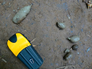
I stopped and looked at animal tracks, Tui thought them wild pig and large deer. People sometimes drive a cow or a pig in to town to sell for cash money, and the tracks might well have been from them, yet I hadn't seen any other tracks on the walk. In the forests around my house I recognise differences between the tracks of the deer, elk, moose, and domestic cow, in Laos not so much, even the cows are different. Guang yai (Sambar) are still around even if not as common as the smaller muntjak, and certainly wild pigs are plentiful. A carnivore scat had me guessing. There are two kinds of big cats and two canines, and two species of bear.


gps and carnivore scat


 Pig Droppings


I was sure it wasn't one of the two canines, too small, and not tapered at the end. The larger of the canines is called Ma Nhai as I remember (in Lowland Lao Language). I remembered it because of it's similarity to Ma Hai which is mad dog which of course I'd never use to describe a person, maybe I have it wrong anyway, and the peoples who live where the Ma Nhai lives speak other languages than Vientiane Lao so who knows what it's really called. We call it Dhol, and there is no love lost between the upland peoples and the dhol, not only because of the mutual competition for food.

Dhole from a camera trap by the WCS
The Dhol hunts in packs similar to our wolf, overwhelming it's quarry by sheer numbers and beginning their feasts by ripping out and eating the guts of the often still alive prey. Akha I talked to said they will bite people, no wonder they don't like the dhol. Bear droppings can vary, mostly I've seen bear scat when they are feeding on grubs, ants, and berries, or grass in the spring, this didn't look like either.


Clouded Leopard from the WCS
That leaves cat, which kind of goes with it's not twisted shape and no sign of vegetables. I've no way to tell the cats apart or even hazard a guess except that it had to be one big enough to eat deer. Immature tiger or leopard or clouded leopard?

Concrete Bridge. The most ambitious structur of the trail.
Past half way to Nambo is a landmark. A concrete bridge over the largest tributary to the Nam Long on the trail. We stop for a break and to eat the barbecued dove and sticky rice I bought in the market the night before. We eat the whole thing bones and all, I think Tui spit out the skull.

Well before dusk we begin to hear chickens and the trail once again is worn by the steps of many feet.

I hear children, smell smoke.

Through the trees, Nambo.
First Glimpse

So Fa So Good


The Mekong just below Xienkok, the Nam Fa joins just out of the photo to the left

There is a steep sided valley tucked away in the mountains of Loas. It’s not on the way to anywhere. The river that flows through this valley crosses only one road far upstream and runs for 110 kilometres undisturbed until it empties into the Mekong unnoticed just below Xiengkok. Nature has also done her part to shield this valley from the covetous eyes of the modern world. Guarding both sides of the valley are steep mountains covered in thick forest, up and downstream powerful rapids make the river unavigatable by even the smallest open boat.

On the south bank of this valley on a sloped bench well above the reach of even the highest flood waters lies a tidy small village called Mongla.


Mongla..... I used the telephoto on my mini zoom to glass the town from 4km away, above Jakune. Large diptocarps rise above the canopy, tilled fields at higher elevations behind the village.

Mongla is not totally isolated. Fit and strong adults make a long one day walk to Muang Long or even Xienkok. They bring back manufactured items, such as lead for shot, fishhooks, gasoline for the generator, even tin for the roofs of the well off. But until recently the outside world had hardly made an impression on the remote valley and no one ventured in.


The Naiban of Mongla and a young boy who has been studying Laotian returning from Muang Long with fuel, a bucket, a woven mat, and some other manufactured goods. This is the ford below Jakune in the dry season. The flow is about ten cubic meters per second down by the Mekong, less than a tenth the volume of the wet season. Translation ; in August this river be rippin.

The people of this valley are Akha, the men can recite their lineage back to common ancestors with all the other Akha of Phongsali, Thailand, China, or wherever. They grow corn and rice above the river on the higher slopes of the mountains. For some reason they leave the trees and forests of the bottomlands uncut. Perhaps some sort of taboo reinforcing good conservation practices.

The trees are some of the tallest and oldest I’ve ever seen in Laos. Maybe it’s just the way they grow so close together amongst the large boulders. The trail is forced to climb up and over and around the roots of the trees in the perpetual twilight of the deep forest. Here the large predators and their prey survive in high numbers, not yet hunted for sale to the underground trade in tiger parts.

Tigers and leopards,
barking deer guar,
bears and civets,
slow loris sambar.


homemade muzzle loader it shoots a very small lead bullet with black powder

Fish eagle fly away,
Jakal can run.
What of the marten and badger,
For them it’s no fun.


Plants and vines growing on tree trunk

The other day bored and googling I came across this web site

Nam Fa Hydropower Project

I quickly scrolled through the article then slowly absorbed the map which is below.


When I enlarged the map all was fuzzy, still I remember enough of the river to recognise the basic lay of things. The Nam Fa trends west and joins a major tributary (Nam Kha) before joining the Mekong itself. I scrolled on back to the technical page. Max height 79 meters, ten kilometre access road. I could see the reservoir not quite reaching Vieng Phouka.

I already knew that many hydroelectric dams had been approved, on the Mekong, in Southern Laos, and a series of dams are planned to destroy almost all of the Nam Ou. I wasn’t surprised really but seing it in black and white really set me back on my heels. Knowing what the people looked like and having slept in their house and eaten their food didn’t help. They weren’t just any people.


Naiban Jakune


Naiban Mongla

Wife Naiban Mongla

Only in reading backwards to search for the start date and for particulars on where the access road would go did I realize the project had been discarded as not profitable enough. I hope it becomes less profitable as time goes by.


Nam Fa looking downstream from the ford below Jakune. After a short while the forest becomes very old and deep.

The following are the visits to the Valley that the Nam Fa runs through so far as I know.

At the beginning of the millennium Wildside Expeditions began to make an attempt to market the idea of a white water rafting trip to the area following their foray down the river on behalf of UNESCO and the Nam Ha Eco tourism folks. Writing in the advertising literature for a trip itinerary the writer, whom I assume must be Bill Tuffin of The Boat Landing Ecotourism Lodge, said, “ The Nam Fa offers one of the most pristine tropical river environments left on earth.”

The wildlife survey down the river by Wildside was the first known instance of outsiders entering the area. I don’t know if they were able to find any takers for their proposed 7 day raft trip. In 04 a mixed group of kayakers including Japanese and Lao nationals also paddled down the river. The rapids are rated at class IV, not too difficult for experienced kayakers, but not the kind of thing for the neophyte.

Beginning in the dry season of 06 Tui the manager of the tourism office in Muang Long started to take trekkers over the mountains on guided walks into the valley. He first took a pair of unknown hikers, then his friend Somjit took a very fast lone Scandinavian guy. Early in the dry season of 06/07 I hiked in with one of Tui’s students, Si Phan guiding me. Later in February 07 Tui hiked in for a second time with a trio of Italians. Even though the Italians were young fit twenty some things they didn’t reach Mongla on the second day until late in the evening. Just after that I too took my second hike, my guide this time was Somjit also his second walk into the valley.

I know that Sak the director of the agricultural department in Muang Long also hiked into Nambo and I assume Jakune as there were also public service health care type posters there. Probably he and Tui were assessing the viability of trekking in the area.

All in all six small groups of two or three people have headed into the valley of the Nam Fa, probably more by now.

I myself have entered or left by four different routes. The first time by cutting over to Nambo then down to Jakune. The river was still too high for crossing to Mongla and we hiked back up on the ridge to the north and tried to follow it down to Xiengkok. We got lost. Not lost lost, just couldn’t find a trail so we walked out to the road.

The first house we came to while headed for the road was perched on a steep side slope. The woman there seemed alone except for five or six dogs that were going wild barking and growling. At the time I thought that it must be a waste to feed so many dogs, now I realize why they kept so many, Asiatic Tiger.

The second time in we walked directly to Mongla due South of Muang Long by cutting over the crest of Phou Mon Lem and across the river below Jakune. We exited by crossing the Nam Fa a couple kilometres downstream of Mongla and regaing the ridge which we followed to Som Pan Yao and out to Xiengkok.


The bright wide blue lines are rivers, Nam Ma up top and Nam Fa below. The smaller darker blue lines are the various routes I walked in and out to the valley as best I remember and the red dots are also where I guess villages to be, from left to right, Som Pan Yao, Mongla, Jakune, and Nambo. Pink dots are abandoned villages one on ridge above Nam Ma valley and the other Jakune Gao.

A look at the map of the Nam Ha NBCA on the Boat Landing web site reveals lots of little animal profiles all over this area and many small house symbols indicating a village. You can easily see the tributary of the Nam Ma in Muang Long heading east and the proliferation of animal signs between it and the Nam Fa to the south. Someone went in there and spotted those animals or their tracks.

Map of the Nam Ha Protected Area on Boat Landing Web Site showing villages and animal locations

I know that Bill Tuffin worked in bringing health care to the area around Muang Long in the 90s, I would have to assume that he and others made perhaps quite a few trips in to the higher elevations and also down into the northern side of the river. Lots of animals are marked on his maps, and towns along both the tributary to the Nam Ma and the north side of the Nam Fa. I suspect many of the towns are now gone or moved. Nambo seems to be much closer to Vieng Phouka than I thought.. And I know one of the village symbols must be the recently abandoned Jakune Gao.

At least three large villages that I know of have moved either to another location or out to the road since this map was made. I covered a small portion of this area, there must be many more relocated ban nock.

The map from The Boat Landing has been invaluable in trying to make sense of where things are. I also cross reference between Google Earth and my old topos that date back to the war. It’s hard trying to remember the lay of the land from some walks I took a year ago. Especially as I was walking as fast as I could just to keep up. But then I am supposed to be able to keep my sense of direction while covering long distances off the trail, it‘s my background. It’s gratifying to see the three sources of information seeming to match my memory. The more I look at the maps and try to remember the shape of the hills, the more the maps and my memories seem to coalesce into a series of overlays in my minds eye with some points in common to all.

The distances between villages is prohibitively far. I don’t see how they can run treks in this area without some places to sleep halfway between the villages. One way or another more and more trips will be made into the valley that surrounds the Nam Fa. My only wish is that future walkers can also see those ancient trees with the wide buttressed trunks, and a wild river not yet dammed.


Ban Nambo

Key: Nam Fa

the Communist Pathet Lao took control of Vientiane and ended a six-century-old monarchy. Initial closer ties to Vietnam and socialization were replaced with a gradual return to private enterprise, an easing of foreign investment laws, and admission into ASEAN in 1997. Nam Fa Nam Fa
Older Posts Home