Burma - Hot History Lesson
I saw this video clip over on a blog called friscodude. The blog itself is worth a look. Written by a travel writer, Carl Parkes, based in Thailand, it is Asian themed but not necessarily restricted to travel. The writing is good and there's often new material.
Craig Schuler's Photos

Self Portrait by Craig Schuler at the Chinese border Phongsali Province Laos. Abandoned Casino in background
Craig studied Thai language formally, and then taught himself Lao language. He gets on well with people and that's obvious from his photographs. People enjoy having him take their picture.
Craig's latest series called sitting on top of a million elephants is kind of a play on words. Laos is called the land of a million elephants and the province where Craig took his most recent series of pictures is the northernmost province in Laos extending by itself way up into the space between Vietnam and China. Not only are the photos from this northernmost province, they are also from the most northern district within that province. Truly Sitting On Top Of A Million Elephants
The name of the district is Nyat Ou, and the Province is Phongsali. I visited that district briefly while in Phongsali at Craig's recommendation. It was everything he had described and more. Ou Tai was remote and seemingly influenced very little yet by the rest of the world.
I'm not sure how many photos are in this set. Many more than any I've ever seen before from Craig. Usually he's very stingy with the photos. Perhaps he had many more "keepers" with this batch.If the links don't show about 100 or more black and whites of rural Laos, email Craig and demand he make the images permanently available for view.
Since I originaly posted this, things have changed. There now seem to be 12 photos all looking kind of like old colour prints, I think this is, as as called on his link to as "treated colour". Interesting to see them first as black and white, and now as faded colours. Some of the images I remember from a year ago as having vibrant but natural seeming colours. I'll have to watch and see what's next.
Update on the update. It seems as if Craig didn't get much response on the original series of black and whites, so he opted for the fall back photos. Craig promises to make the black and whites available again soon. Send an email to Craig by clicking here and going to the portion of his web site that says "contact" tell him to bring back the black and whites
He has had two other sets of color photos on the same web site. I liked both of the other sets, they were tremendous in their own right, but these photos seem to build on his earlier work and go beyond them. The black and white adds to the feeling of timelessness. If you didn't know already when they were taken you might think they are from ten, twenty, fifty or more years ago.
Of Laos and Laotians

Some Lao people in Laos. Left to right, baby Namphone, her mom Aunt Kien, Sengthian, Aunt Hong, Creag.
A great post follows about a controversial subject from a Lao American young woman whom I just happen to agree with, or else why quote it, right?
The quote within a quote, is from her blog lao-ocean girl I think the quoted article within the quoted blog is by Grant Evans the preeminent Lao scholar. (correction it's by both Grant Evans and Nick Enfield published in the Vientiane Times in 1998)
This part by LA-ocean girl
I’m Laotian-American, but currently live in Korea. I’ve travelled around SE Asia and have met other backpackers who have travelled to Laos. There always seemed to be a discrepancy as to what the country was called. There was one group, including myself, who called it Laos. Then there was the other group, who thought they were "in" with the locals, and called it Lao. Sometimes I would correct people, but most of the time people mentioned the country in passing, so I let it slide. In addition, who was I, to correct foreigners that I didn’t even know. This may seem like a trivial point, but it’s always irritated me. Sure, the local people called their country Lao, but it was in the context of "Prathet Lao" or "Muang Lao". Literally translated, they both mean "Lao land" and "Lao country". Whenever I talked to my parents about Laos, I always refer to it as "Muang Lao," but that’s because I actually speak Lao. It just seemed pretentious of foreigners to call the country Lao. Aarrrgghh! But that’s just me… I don’t tell my friends that my trip to "Italia" was wonderful, I say "Italy."
Below is an article I found about this topic. It has some insightful linguistic information.
This part by Grant Evans and Nick Enfield. Grant Evans needs no introduction to those who read about Laos. Nick Enfield I hadn't heard of as I don't really speak Laotian, (I fake it and smile a lot) People who are into it would probably call him an ethno linguist or something.publications of Nick Enfield
There appears to be confusion among some foreigners in Laos about how to spell the name of the country known today by its official name, the Lao People’s Democratic Republic. In particular there is confusion about whether to refer to the country as ‘Lao’ or ‘Laos’ when writing or speaking in English. Historically it has been common for English writers to refer to the country as Laos when not using the country’s official title, and this is the standard form outside of the LPDR today. So why confusion inside the country? One source of the confusion for some foreigners appears to be that when they come to the country they discover that in the Lao language, the country’s name has no final ’s’. Indeed, there are no words at all in Lao which have a final ’s’. Some people therefore seem to think that it is more correct to say, for example, that Vientiane is the capital of ‘Lao’ rather than ‘Laos’. But where does this logic come from? There are a great many country names that are pronounced quite differently in English, or indeed are completely different words in the home language. An outstanding example is the country name ‘China’ which actually does not exist in any variety of Chinese. In Mandarin, the official language of China, the country is referred to as ‘Zhong Guo’. In Lao, China is referred to as ‘Jiin’. Another example is India, whose name in Hindi is ‘Bharat’, a completely different word to the English. Further away from the Asian context, inhabitants of the country called ‘Finland’ call their homeland ‘Soumi’. A better known European example is Germany, which is known as ‘Allemagne’ in French, and ‘Deutschland’ in the native German. All these examples show that it is quite common not only for the name of a country to be pronounced quite differently in various languages, but indeed may be a completely different word. We have heard reports where foreign experts have been instructed by some Lao officials not to use the term ‘Laos’ in their reports, but to call the country ‘Lao’ instead. "Laos does not exist", they have been told by officials. So, for example, we can find the following sentences in a recent UN document: "Reduction of rural poverty is a main motivating factor for rural development in Lao. At its stage of development, rural poverty reduction in Lao will come by increasing rural employment possibilities…" The uses of ‘Lao’ in both cases could have been ‘Laos’, and we would suggest that it is more desirable to use ‘Laos’ in these contexts. Only if the document had used Lao PDR’ in both cases would it have been correct to use ‘Lao’. It is a puzzle to us why some officials would issue such instructions to foreign experts. Despite that fact that the Lao themselves have their own distinctive ways of pronouncing the names of other countries, we can only think that this instruction is some kind of zealous nationalism which insists that foreigners use the name ‘Lao’ in the same way the Lao do in their own language. Such officials may be unaware that the Lao also force the names of other countries to conform to their own pronunciation conventions.
Consider the ways in which the Lao language renders the names of various foreign countries. While in the cases of Vietnam and Cambodia, Lao pronounces the names of these countries quite like the natives do, there are others that are extremely different in terms of pronunciation. Two good examples from Europe are Austria and Belgium. These are pronounced in Lao as something like ‘Ottalik’ and ‘Bensik’ respectively (from French Autteriche and Belgique). It so happens that English has a huge range of possible sounds that can appear at the end of a word. In English, the rounding-off of the word ‘Laos’ with an ’s’ is a very typical thing to do, as any Lao who struggles with an ’s’ on the end of every second word will attest. In Lao, however, and many other languages of Southeast Asia, it is impossible to finish a word with sounds like ’s’,'f’,'th’, and so on. In Cantonese, for example, there is a tendency to add an ‘ee’ sound to the end of words that end with ’s’. ‘Price’, for example, is pronounced ‘pricey’, or ‘tips’ becomes ‘tipsy’, and so on. Cantonese does not have a word-final ’s’ sound, and so it has to add a vowel so that the ’s’ can be colloquially pronounced. This process of changing the pronunciation of a borrowed word to conform to the conventions of the borrowing language is called indigenisation. Laos with an ’s’ was one solution in English for the country’s name. It could have been ‘Lao’, but it may well have been ‘Lao-land’, by literal translation from the Lao. This of course happened with Thailand when ‘Prathet Thai’ was translated as ‘Thai-land’. But, for reasons which are obscure to us, ‘Pathet Lao’ is not ‘Lao-land’ and nor is it a country called ‘Lao’. Indeed, the latter usage is quite marked in English, and when used by foreigners seems almost pretentious. Of course ‘Lao’ is perfectly correct in English when used as an adjective. For example: a Lao person, the Lao language, a Lao poem, etc. One other possibility that has tended to fall into-use is ‘Laotian’. So one can say: a Laotian person, the Laotian language, Laotian poem. This, however, seems to be losing out to the more economical ‘Lao’.
The old saying (in English) goes: "When in Rome do as the Romans do", but only if you are speaking Italian should you say ‘Italia’. Similarly in Laos, only if you are speaking Lao do you need to say ‘Lao’ when referring to the country.
Antelope Laap

Recently Bryan, the guy who gives me meat, gave me some seal-a-mealed antelope, that somebody gave him. I don’t know the name of the guy who shot it or where. I’m assuming somewhere here in Colorado. I do know he used a 308, another one of those rounds that can knock something over way out yonder.

Having no idea what antelope tasted like I lightly fried some in canola oil. Gamey, kind of like venison. Perfect for a strong Laap.

Before I get into the laap some antelope explaining is in order. Pronghorn Antelope as found in the Americas aren’t really an antelope at all. The only surviving genus of the family Antilocapridae, it’s closest living relative is the giraffe. Yes, I looked it up.
Having worked on the prairies of eastern Wyoming I knew they were extremely fast, according to Wikipedia the only faster animal is the cheetah but the antelope can sustain high speeds for a longer period. Besides being fast they also have exceptional eyesight. If you just try to walk up to normal shooting range they will quickly become a small dot on the horizon.

Back to the laap. I pre-cut some of the ingredients, shallots, garlic, thin sliced lemon grass, regular Thai peppers, cilantro, and lime ready to add. My wife keeps a container of ground up toasted sticky rice in the spice drawer. I fried the ground up antelope, (that’s how it came. I am not too lazy to chop if that’s what you were thinking), turned off the heat and added the shallots and green onions, then a couple spoonfuls of fish sauce, a little bang nua and some pah dek water to taste.

I made the pah dek water by mixing a dab of factory made pah dek with some water in a sauce pan and simmering it until it dissolved. ( a couple of minutes) The pah dek water was key to add some juice to the whole thing and also the pah dek and gamey meat compliment each other. My Lao supervisor chastised me for over cooking the meat. I did not. Turned off the heat just as soon as it began to look like it might cook through. Antelope is just a little dry. I mean the prairie out here is technically a dessert.

Vietnamese Pah Dek in a Jar

Pahdek water yummy

Lastly I stirred in the cilantro, green onions, and hot peppers while squeezing six pieces of lime into it. I like lime juice.
And sticky rice.
Sabai Dii Pi Mai

This is the day before yesterday. It might be new years and the height of the hot season in Laos but it's still snowing here. This photo was at 9:30 AM. The snow is so thick the movement activated light over my garage/shop came on illuminating the rack I have mounted above the big rolling door.
Today is the day they celebrate here, Saturday, I think in Laos it's the next or following day.

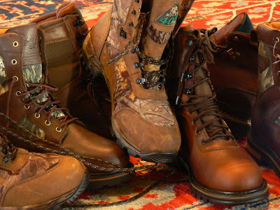
For My Feet
Often I hear people discussing what’s the best thing to wear to go for a walk, specifically “trekking” in South East Asia.
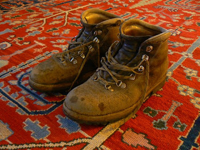
Above my old hiking boots. My first pair I spent a two week pay check to buy, I think they were about $65 in 1974. Eventually I trashed them in the salt water on the back deck an anchor boat in the Gulf of Mexico. An ignominious end for a hand made boot by a master craftsman. This pair I bought later in my mid thirties when I had plenty of money to pay the then price tag of $250. They are called Limmers. A typical yearly production run was a thousand pair. They were made around a wooden last of your foot. Limmer Boots of Intervale NH
A common theme of footwear discussions is why bother carrying boots all the way to Asia, when a pair of sandals might do as well or better. I used to be of the same mind but of late have changed my tune. There are caveats, it all depends on where you are going and how far.
The first guest house I stayed at in Chang Mai was developed around the trekking business. The guides taught me to speak some Thai and explained many seemingly inexplicable parts of Thai culture. When I came back to Thailand to work at first for half a year and later on a one way ticket I always stayed at that guest house when in town, my home away from home.
Eventually one of my friends convinced me to go on a trek. It was the typical two night/three day /elephant ride/rafting thing. Being as I was a non paying guest I missed out on the rafting / elephant walk. I also was extremely sick due to being incautious when peeling the cover off some rambutans. The walking was so easy I was able to keep up without strain, even being sick. Leisurely wanders with convenient rests in closely spaced villages I considered to be the norm.
Laos was different...

Above I’m doing the powder mag traverse at an LZ in southern Idaho. Notice the skid marks from my feet where I’d edged on the bolts during previous post-work workouts. I was an obsessed climber.
During the 80s I did a kind of job that required lots of walking in the mountains of Idaho, Wyoming, Utah, and Montana. Half of our pay was by the mile so we covered a lot of ground very quickly often walking hundreds and hundreds of miles, with weight, over rough terrain. On my feet I’m wearing a lightweight pair of European hiking boots. I used to buy discounted pairs in Boulder or Jackson Wyoming. Pivettas, Fabianos, Lowas, and Galibiers. Returns, last years models, any brand, cheap and high quality were all I cared about. I found it was less expensive to buy them for fifty or a hundred dollars on sale and throw them away when they were worn out rather than resole. I also liked the light weight and close cut.
Many of my friends preferred Galibier Super Guides above. They were heavy and didn’t bend much but they could be resoled, and were indestructible. Good for kick stepping in the mornings when the snow was still frozen.
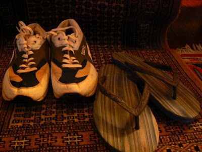
Thinking that walks in Laos would be similar to those in Thailand I took the footwear above on most of my treks. On my very first excursion I took Crocs, a rubber type clog thing. After the second day I switched to the sneakers that I’d carried as backup. Subsequently I wore the sneakers exclusively and the flip flops once I’d reached the villages.
Most of my walks were long drawn out affairs, often going as fast as possible just to make the next village by night. The relocation of many of the villages has caused trails to become obscure and sometimes even disappear. In the wetter seasons there’s lots of slippery mud. In a word footing is usually bad and often worse than that. I did go on one standard commercial trek rated fairly hard but in reality much easier than the more unravelled walks. I think a pair of Tevas or similar would have worked fine. Of course from a stylistic perspective I’d rather go barefoot.
If I ever make it back I swear I’m going to take a good pair of boots with me. Boot technology has changed.
A couple of years ago a neighbour who often works as a hunting guide urged me to hurry on down to Walmart and buy some Herman Survivors as they were on sale. I remember Survivors from when I used to hike as a young teen. High topped leather and heavy. Somewhere along the way the brand got sold and they are now made of cordura, gortex and thinsulate. They are made in China as are almost all boots.
I bought three different styles at that sale, all for around twenty five dollars marked down from fifty or sixty. They were extremely light, water proof in a way my old leather boots could only dream of, and the support was in all the right places without being stiff. A far superior boot for what now amounts to a fraction of an hour of my labour. I was sold.
They are “hunting” boots. Usually having some sort of fashionable camouflage on them somewhere just so you get the idea. They are also high tops and often with some insulation because hunters are often out in the cold. For some reason the big box sporting goods stores clear out their inventory with the seasons. I think it’s cheaper to sell at a steep reduction than to inventory it and sell it to some discounter.
This year I kept my eyes open and bought better brands at a lot larger markdown. My average price was $32, average new prices were $130. Thank you China and the Dominican Republic, just wish we still employed people in our own shoe factories.
Update, I should mention in all honesty that I've had problems with my "buy cheap stuff and just wear it" philosophy. I took two of my unused pair of shoes to Laos and had some uh. . . difficulties. Probably a good idea to take some long walks with any pair of shoes before bringing them with you on the airplane.

Above my old hiking boots. My first pair I spent a two week pay check to buy, I think they were about $65 in 1974. Eventually I trashed them in the salt water on the back deck an anchor boat in the Gulf of Mexico. An ignominious end for a hand made boot by a master craftsman. This pair I bought later in my mid thirties when I had plenty of money to pay the then price tag of $250. They are called Limmers. A typical yearly production run was a thousand pair. They were made around a wooden last of your foot. Limmer Boots of Intervale NH
A common theme of footwear discussions is why bother carrying boots all the way to Asia, when a pair of sandals might do as well or better. I used to be of the same mind but of late have changed my tune. There are caveats, it all depends on where you are going and how far.
The first guest house I stayed at in Chang Mai was developed around the trekking business. The guides taught me to speak some Thai and explained many seemingly inexplicable parts of Thai culture. When I came back to Thailand to work at first for half a year and later on a one way ticket I always stayed at that guest house when in town, my home away from home.
Eventually one of my friends convinced me to go on a trek. It was the typical two night/three day /elephant ride/rafting thing. Being as I was a non paying guest I missed out on the rafting / elephant walk. I also was extremely sick due to being incautious when peeling the cover off some rambutans. The walking was so easy I was able to keep up without strain, even being sick. Leisurely wanders with convenient rests in closely spaced villages I considered to be the norm.
Laos was different...

Above I’m doing the powder mag traverse at an LZ in southern Idaho. Notice the skid marks from my feet where I’d edged on the bolts during previous post-work workouts. I was an obsessed climber.
During the 80s I did a kind of job that required lots of walking in the mountains of Idaho, Wyoming, Utah, and Montana. Half of our pay was by the mile so we covered a lot of ground very quickly often walking hundreds and hundreds of miles, with weight, over rough terrain. On my feet I’m wearing a lightweight pair of European hiking boots. I used to buy discounted pairs in Boulder or Jackson Wyoming. Pivettas, Fabianos, Lowas, and Galibiers. Returns, last years models, any brand, cheap and high quality were all I cared about. I found it was less expensive to buy them for fifty or a hundred dollars on sale and throw them away when they were worn out rather than resole. I also liked the light weight and close cut.

Many of my friends preferred Galibier Super Guides above. They were heavy and didn’t bend much but they could be resoled, and were indestructible. Good for kick stepping in the mornings when the snow was still frozen.

Thinking that walks in Laos would be similar to those in Thailand I took the footwear above on most of my treks. On my very first excursion I took Crocs, a rubber type clog thing. After the second day I switched to the sneakers that I’d carried as backup. Subsequently I wore the sneakers exclusively and the flip flops once I’d reached the villages.
Most of my walks were long drawn out affairs, often going as fast as possible just to make the next village by night. The relocation of many of the villages has caused trails to become obscure and sometimes even disappear. In the wetter seasons there’s lots of slippery mud. In a word footing is usually bad and often worse than that. I did go on one standard commercial trek rated fairly hard but in reality much easier than the more unravelled walks. I think a pair of Tevas or similar would have worked fine. Of course from a stylistic perspective I’d rather go barefoot.
If I ever make it back I swear I’m going to take a good pair of boots with me. Boot technology has changed.

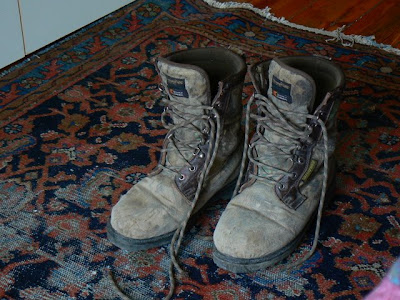
A couple of years ago a neighbour who often works as a hunting guide urged me to hurry on down to Walmart and buy some Herman Survivors as they were on sale. I remember Survivors from when I used to hike as a young teen. High topped leather and heavy. Somewhere along the way the brand got sold and they are now made of cordura, gortex and thinsulate. They are made in China as are almost all boots.
I bought three different styles at that sale, all for around twenty five dollars marked down from fifty or sixty. They were extremely light, water proof in a way my old leather boots could only dream of, and the support was in all the right places without being stiff. A far superior boot for what now amounts to a fraction of an hour of my labour. I was sold.
They are “hunting” boots. Usually having some sort of fashionable camouflage on them somewhere just so you get the idea. They are also high tops and often with some insulation because hunters are often out in the cold. For some reason the big box sporting goods stores clear out their inventory with the seasons. I think it’s cheaper to sell at a steep reduction than to inventory it and sell it to some discounter.

This year I kept my eyes open and bought better brands at a lot larger markdown. My average price was $32, average new prices were $130. Thank you China and the Dominican Republic, just wish we still employed people in our own shoe factories.
Update, I should mention in all honesty that I've had problems with my "buy cheap stuff and just wear it" philosophy. I took two of my unused pair of shoes to Laos and had some uh. . . difficulties. Probably a good idea to take some long walks with any pair of shoes before bringing them with you on the airplane.
So Fa So Good

The Mekong just below Xienkok, the Nam Fa joins just out of the photo to the left
There is a steep sided valley tucked away in the mountains of Loas. It’s not on the way to anywhere. The river that flows through this valley crosses only one road far upstream and runs for 110 kilometres undisturbed until it empties into the Mekong unnoticed just below Xiengkok. Nature has also done her part to shield this valley from the covetous eyes of the modern world. Guarding both sides of the valley are steep mountains covered in thick forest, up and downstream powerful rapids make the river unavigatable by even the smallest open boat.
On the south bank of this valley on a sloped bench well above the reach of even the highest flood waters lies a tidy small village called Mongla.

Mongla..... I used the telephoto on my mini zoom to glass the town from 4km away, above Jakune. Large diptocarps rise above the canopy, tilled fields at higher elevations behind the village.
Mongla is not totally isolated. Fit and strong adults make a long one day walk to Muang Long or even Xienkok. They bring back manufactured items, such as lead for shot, fishhooks, gasoline for the generator, even tin for the roofs of the well off. But until recently the outside world had hardly made an impression on the remote valley and no one ventured in.

The Naiban of Mongla and a young boy who has been studying Laotian returning from Muang Long with fuel, a bucket, a woven mat, and some other manufactured goods. This is the ford below Jakune in the dry season. The flow is about ten cubic meters per second down by the Mekong, less than a tenth the volume of the wet season. Translation ; in August this river be rippin.
The people of this valley are Akha, the men can recite their lineage back to common ancestors with all the other Akha of Phongsali, Thailand, China, or wherever. They grow corn and rice above the river on the higher slopes of the mountains. For some reason they leave the trees and forests of the bottomlands uncut. Perhaps some sort of taboo reinforcing good conservation practices.
The trees are some of the tallest and oldest I’ve ever seen in Laos. Maybe it’s just the way they grow so close together amongst the large boulders. The trail is forced to climb up and over and around the roots of the trees in the perpetual twilight of the deep forest. Here the large predators and their prey survive in high numbers, not yet hunted for sale to the underground trade in tiger parts.
Tigers and leopards,
barking deer guar,
bears and civets,
slow loris sambar.

homemade muzzle loader it shoots a very small lead bullet with black powder
Fish eagle fly away,
Jakal can run.
What of the marten and badger,
For them it’s no fun.

Plants and vines growing on tree trunk
The other day bored and googling I came across this web site
Nam Fa Hydropower Project
I quickly scrolled through the article then slowly absorbed the map which is below.

When I enlarged the map all was fuzzy, still I remember enough of the river to recognise the basic lay of things. The Nam Fa trends west and joins a major tributary (Nam Kha) before joining the Mekong itself. I scrolled on back to the technical page. Max height 79 meters, ten kilometre access road. I could see the reservoir not quite reaching Vieng Phouka.
I already knew that many hydroelectric dams had been approved, on the Mekong, in Southern Laos, and a series of dams are planned to destroy almost all of the Nam Ou. I wasn’t surprised really but seing it in black and white really set me back on my heels. Knowing what the people looked like and having slept in their house and eaten their food didn’t help. They weren’t just any people.

Naiban Jakune

Naiban Mongla

Wife Naiban Mongla
Only in reading backwards to search for the start date and for particulars on where the access road would go did I realize the project had been discarded as not profitable enough. I hope it becomes less profitable as time goes by.

Nam Fa looking downstream from the ford below Jakune. After a short while the forest becomes very old and deep.
The following are the visits to the Valley that the Nam Fa runs through so far as I know.
At the beginning of the millennium Wildside Expeditions began to make an attempt to market the idea of a white water rafting trip to the area following their foray down the river on behalf of UNESCO and the Nam Ha Eco tourism folks. Writing in the advertising literature for a trip itinerary the writer, whom I assume must be Bill Tuffin of The Boat Landing Ecotourism Lodge, said, “ The Nam Fa offers one of the most pristine tropical river environments left on earth.”
The wildlife survey down the river by Wildside was the first known instance of outsiders entering the area. I don’t know if they were able to find any takers for their proposed 7 day raft trip. In 04 a mixed group of kayakers including Japanese and Lao nationals also paddled down the river. The rapids are rated at class IV, not too difficult for experienced kayakers, but not the kind of thing for the neophyte.
Beginning in the dry season of 06 Tui the manager of the tourism office in Muang Long started to take trekkers over the mountains on guided walks into the valley. He first took a pair of unknown hikers, then his friend Somjit took a very fast lone Scandinavian guy. Early in the dry season of 06/07 I hiked in with one of Tui’s students, Si Phan guiding me. Later in February 07 Tui hiked in for a second time with a trio of Italians. Even though the Italians were young fit twenty some things they didn’t reach Mongla on the second day until late in the evening. Just after that I too took my second hike, my guide this time was Somjit also his second walk into the valley.
I know that Sak the director of the agricultural department in Muang Long also hiked into Nambo and I assume Jakune as there were also public service health care type posters there. Probably he and Tui were assessing the viability of trekking in the area.
All in all six small groups of two or three people have headed into the valley of the Nam Fa, probably more by now.
I myself have entered or left by four different routes. The first time by cutting over to Nambo then down to Jakune. The river was still too high for crossing to Mongla and we hiked back up on the ridge to the north and tried to follow it down to Xiengkok. We got lost. Not lost lost, just couldn’t find a trail so we walked out to the road.
The first house we came to while headed for the road was perched on a steep side slope. The woman there seemed alone except for five or six dogs that were going wild barking and growling. At the time I thought that it must be a waste to feed so many dogs, now I realize why they kept so many, Asiatic Tiger.
The second time in we walked directly to Mongla due South of Muang Long by cutting over the crest of Phou Mon Lem and across the river below Jakune. We exited by crossing the Nam Fa a couple kilometres downstream of Mongla and regaing the ridge which we followed to Som Pan Yao and out to Xiengkok.

The bright wide blue lines are rivers, Nam Ma up top and Nam Fa below. The smaller darker blue lines are the various routes I walked in and out to the valley as best I remember and the red dots are also where I guess villages to be, from left to right, Som Pan Yao, Mongla, Jakune, and Nambo. Pink dots are abandoned villages one on ridge above Nam Ma valley and the other Jakune Gao.
A look at the map of the Nam Ha NBCA on the Boat Landing web site reveals lots of little animal profiles all over this area and many small house symbols indicating a village. You can easily see the tributary of the Nam Ma in Muang Long heading east and the proliferation of animal signs between it and the Nam Fa to the south. Someone went in there and spotted those animals or their tracks.
Map of the Nam Ha Protected Area on Boat Landing Web Site showing villages and animal locations
I know that Bill Tuffin worked in bringing health care to the area around Muang Long in the 90s, I would have to assume that he and others made perhaps quite a few trips in to the higher elevations and also down into the northern side of the river. Lots of animals are marked on his maps, and towns along both the tributary to the Nam Ma and the north side of the Nam Fa. I suspect many of the towns are now gone or moved. Nambo seems to be much closer to Vieng Phouka than I thought.. And I know one of the village symbols must be the recently abandoned Jakune Gao.
At least three large villages that I know of have moved either to another location or out to the road since this map was made. I covered a small portion of this area, there must be many more relocated ban nock.
The map from The Boat Landing has been invaluable in trying to make sense of where things are. I also cross reference between Google Earth and my old topos that date back to the war. It’s hard trying to remember the lay of the land from some walks I took a year ago. Especially as I was walking as fast as I could just to keep up. But then I am supposed to be able to keep my sense of direction while covering long distances off the trail, it‘s my background. It’s gratifying to see the three sources of information seeming to match my memory. The more I look at the maps and try to remember the shape of the hills, the more the maps and my memories seem to coalesce into a series of overlays in my minds eye with some points in common to all.
The distances between villages is prohibitively far. I don’t see how they can run treks in this area without some places to sleep halfway between the villages. One way or another more and more trips will be made into the valley that surrounds the Nam Fa. My only wish is that future walkers can also see those ancient trees with the wide buttressed trunks, and a wild river not yet dammed.

Ban Nambo
Subscribe to:
Posts (Atom)