Laos

Showing posts with label Laos. Show all posts
The area east of the Mekong, however, was soon wrenched back from Siam by the French Laos. the Communist Pathet Lao took control of Vientiane and ended a six-century-old monarchy. Initial closer ties to Vietnam and socialization were replaced with a gradual return to private enterprise, an easing of foreign investment laws, and admission into ASEAN in 1997.

Hmong House


The Hmong guy Lao Bii, was Tui’s friend, they knew each other from when Tui’d been to Nambo before.

I'm going  to apologise in advance for anything I get wrong. I don't know much about the Hmong. I've met and talked to plenty in Thailand, China, and America, but I really don't know much about the way they live in the more traditional setting of rural Laos.

At first we waited for Lao Bii in the yard, he was out hunting birds like all guys do at the end of the day. With seemingly every guy in the village out looking for birds every afternoon you have to wonder how there are any birds left. But there are, and there always have been.


When Tui's friend returned we went inside. After setting our packs down, slipping off our boots and donning flip flops, we went to off find people I’d taken photos of two years before. I always try to hand out a copy of a photo to anyone I take a picture of.


We also stopped in and said hi to the soldiers stationed in the village, and Tui showed them some sort of documentation authenticating my permission to be gallivanting about.. Since my last visit the government sent fourteen soldiers including two political officers and a teacher to live in the village.

On realizing that I could follow the conversation I remarked to one of the soldiers, “you speak Lao”, he grunted and looked at me as if to say “what were you expecting, Swahili?” The lingua franca of this district is Lu, I usually understand none of it. The soldier was of Kahmu ethnicity, perhaps from an entirely different region of Laos. These soldiers were from the central government, not the provincial authorities.


Luang Namtha province is an opium producing area, and the government is interested in curtailing the production. The opium grown isn’t refined but rather consumed by locals as a recreational drug or as medicine. Opium is also the primary cash crop in the area, used to buy lead shot, LED light bulbs, batteries, antibiotics, clothes, and all other manufactured goods from the outside world.


Things have changed for the better in Nambo in the two years since I’d last seen it. The kids seemed healthier and had better clothes, houses had been enlarged and improved. I stopped in front of the house I’d stayed in before and watched the building of a new house. The village is made of combined Lahu and Hmong ethnic groups, an attempt by the government to form larger villages, why I’m not sure.


Photo from 06 of moonrise and dead tree

 you can see the same dead tree as in the moonrise  photo above, same tree, just a little deader.


The view to the south is mostly of Mount (Phou) Mon Lem. Tui was so used to seeing the mountain from a different side that at first he didn’t believe it to be the same hill. The Hmong guys eavesdropping set him straight. It’s easy to mistake a mountain that has such a large base, the perspective is much different depending on how close you are to which side. Phou Mon Lem and it’s flanks separate the drainage of the Nam (river) Fa and the Nam Long with the ridge extending all the way down to the Mekong.
Phou Mon Lem


With the onset of dark we returned to Lao Bii's house. Tui told me that a couple of years ago our host had been required to turn himself in at the district capital and submit to being placed under arrest and jailed for shooting a nuah pah (wild cow). I don’t know if it was a banteng or a gaur, both animals are against the law to hunt in Laos and probably endangered. His family had to gather up $1,000 to pay the fine to release him. That's a lot of money for a subsistence farmer.


Gaur, one of the largest land animals. Photo is from some travel company in Thailand that does trips to Khao Sok National Park, one of the few photos I could find from the wild, (don't like zoo photos). I lost the link, if anyone reading knows the name of the company please email and I'll include a link, credit where credit is due.


In the area around Muang Long there is no international trade in endangered wildlife. The route to China is long and the authorities are aware of most that happens in their district. The rules regarding which species of big game to hunt are followed. Medium sized deer, bamboo rat, pig, that sort of thing are allowed, large and perhaps endangered animals aren’t.


No one really knows how many of which species exist in Laos. In the state where I live in the US they have done extensive research on cougars over many decades and yet current population estimates rage from five to seven thousand animals. That’s a pretty inaccurate number given all the radio collaring, DNA of scat samples, and computer modeling that is done. In Laos where there are none of these tools and very few scientists doing research all numbers are determined using the WAG method. (Wild Ass Guess)


Looking at things from the perspective of indigenous peoples you can see where there might be some consternation. The same people have been living in the hills of Laos for centuries, using the same methods of hunting and farming. Species endangerment, and habitat loss have nothing to do with the way they hunt or farm, and everything to do with the way we buy patio furniture and the way the Chinese buy cars with tires.
Phou Mon Lem on Google Earth without vertical exageration. Ignore the "route 3" cutting over the top, no idea how lines are drawn on google maps. The yellow line in the far distance is the international border of Laos/Burma formed by the Mekong.


A few years ago a wild elephant in musth appeared down by Xiengkok and started trampling houses and killing people. The authorities sent people ahead of the animal and attempted to warn those in it’s path while desperately seeking permission to kill the thing. The head of the district contacted the provincial governor who contacted his superiors in Luang Prabang and eventually permission was granted from the prime minister in Vientiane. No one wanted to take responsibility.


I got this story after spotting a large bone in the restaurant called Joey. I knew the bone was way too big for any animal I’d ever heard of. People figure it swam the Mekong from Burma in that wild testosterone induced craziness that male elephants sometimes go through. There are no wild elephants in Bokeo or Luang Namtha side of things, maybe up by that transnational protected area close to Boten and Sipsongbana, but not down by Long and Xiengkok.


Elephant Bones


With the sun fully down we returned to our host’s house. I took a more leisurely look at the inside.


The Hmong live differently from the lowland Lao and Tai I’m used to. For one thing they live on the ground not up on stilts. Living on the mountain they are never in danger of flood. The roof was a very nice split wooden shake, no need to constantly replace roof straw or put up with the drops of condensation off a metal roof.
Lao Bii and his youngest


The house seemed quieter, no constant squawking of chickens or snorting of pigs from under foot. Warmer too, no breeze blowing through the split bamboo floor. The floor itself though of dirt is not dirty but shiny from the polishing of many feet.


The fire is in a large square block of mud/clay. The wood is fed from the front and a very large wok sits snugly on a hole on top. It is a very basic stove, saving on firewood and heating the house when the fire is out via the large mass of the clay.


I notice they cook rice differently also. First in the wok until the water boils, then transferred to a basket which sits on top of the boiling water and the rice is steamed until done. I like it. The rice is wetter, and I like my rice wet. Below the roof, strung from the rafters so to catch the smoke, a roll of sausage made from the small intestine of a pig and unidentified hunks of fat.

Sausage and probably pig fat

In the days before LED lights (like four years ago) the lamps from fat were the only illumination. The fat still serves as a hedge against lean times, hard to go hungry with fat hanging in the ceiling


I’ve no recollection of the night, only of the eldest wife blowing the coals to start the morning fire before sunup.


Meet the hospitable, smiling and welcoming people of Laos. Hmong and Laotians, young and old, the Lao people are some of the friendliest people in South East Asia.

See it for yourself! Click Here for Exotissimo's Laos Tour Collection

The Trail to Nambo

Tui makes a last phone call while still within range of phone tower.


The trail to Nambo is a relative superhighway. It is by far the most gradual and fastest trail for hundreds of square miles. Using the cut of the the Nam Long through the mountains the trail steadily gains elevation while never resorting to switchbacks or steep sections. I've walked the trail twice, once back in 06 and more recently in the winter of 09. The trail provides easy access to the upper drainage of the Nam Fa. The trail is also used by all the Lao Sung as a quick access to the market at Muang Long. Bear in mind that tiny market is the biggest one in north western Laos beyond Muang Sing, and Burma across the river is even less traveled, it's a long way upriver to China or down to Thailand.


In 06 I saw the tracks of a single motorcycle made at the beginning of the dry season. I think it was a rider from that GT Riders club out of Chang Mai Thailand. They would of had to have pushed and drug the bike up and down many of the numerous stream crossings. None of the villages have motorcycles or other transport. I assume it was an off road bike, one of the last to have made the transect to Viengphouka. A few years ago there were temporary bridges strong enough to drive on with one of those one cylinder Chinese tractor things. The bridges were made by felling two large logs across the streams and covering the logs with branches and then mud and dirt. The logs have rotted away and are gone. Now there are small single slippery logs strong enough to support a person. I'd think it would more time and effort now to drag and carry a motorcycle up and down the many stream crossings than to just walk.
Stream Crossing

If you look on maps they show the trail as a full fledged road to Viengphouka, maybe it was in some one's imagination once, and it certainly might be at some future date, but for now it's falling back into forest. The dirt was hacked out of the hillside to make a flat graded path, and it was never wide enough for a two track even when new.
Google Earth-mountains beyond mountains beyond mountain
I don't know where the funding to work on upgrading the original trail came from. I've seen road crews making similar tracks. Fifty people hacking at the hillside with those heavy hoes they use to farm. Was this one of the many plans for crop substitution? A way to bring crops or forest products to market?

Tui from the tourism office asked me if I thought it was 20 kilometers. I guess so, I'm not the best at figuring kilometers, feels like ten miles anyway, maybe twelve or more. The road roughly follows the south side of the Nam Long but high above the river. I'm not sure of the elevation gain but it does go up all the way to Ban Nambo. There's a village somewhere, down by the river I suspect, I've never been there.

Stile


At the near end of the trail there are fences to keep cattle from wandering.. In English we call these fences "stiles". A person can walk up the ladder, an animal can't. The hillside drops off so steeply on both sides that the cattle are restricted to the road. As the kilometers pass under our feet most signs of people also pass. Soon we are beyond the distance that most people will reasonably walk to go hunting or gather stuff to sell at the market.


Bamboo in flower?

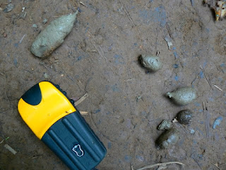
I stopped and looked at animal tracks, Tui thought them wild pig and large deer. People sometimes drive a cow or a pig in to town to sell for cash money, and the tracks might well have been from them, yet I hadn't seen any other tracks on the walk. In the forests around my house I recognise differences between the tracks of the deer, elk, moose, and domestic cow, in Laos not so much, even the cows are different. Guang yai (Sambar) are still around even if not as common as the smaller muntjak, and certainly wild pigs are plentiful. A carnivore scat had me guessing. There are two kinds of big cats and two canines, and two species of bear.


gps and carnivore scat


 Pig Droppings


I was sure it wasn't one of the two canines, too small, and not tapered at the end. The larger of the canines is called Ma Nhai as I remember (in Lowland Lao Language). I remembered it because of it's similarity to Ma Hai which is mad dog which of course I'd never use to describe a person, maybe I have it wrong anyway, and the peoples who live where the Ma Nhai lives speak other languages than Vientiane Lao so who knows what it's really called. We call it Dhol, and there is no love lost between the upland peoples and the dhol, not only because of the mutual competition for food.

Dhole from a camera trap by the WCS
The Dhol hunts in packs similar to our wolf, overwhelming it's quarry by sheer numbers and beginning their feasts by ripping out and eating the guts of the often still alive prey. Akha I talked to said they will bite people, no wonder they don't like the dhol. Bear droppings can vary, mostly I've seen bear scat when they are feeding on grubs, ants, and berries, or grass in the spring, this didn't look like either.


Clouded Leopard from the WCS
That leaves cat, which kind of goes with it's not twisted shape and no sign of vegetables. I've no way to tell the cats apart or even hazard a guess except that it had to be one big enough to eat deer. Immature tiger or leopard or clouded leopard?

Concrete Bridge. The most ambitious structur of the trail.
Past half way to Nambo is a landmark. A concrete bridge over the largest tributary to the Nam Long on the trail. We stop for a break and to eat the barbecued dove and sticky rice I bought in the market the night before. We eat the whole thing bones and all, I think Tui spit out the skull.

Well before dusk we begin to hear chickens and the trail once again is worn by the steps of many feet.

I hear children, smell smoke.

Through the trees, Nambo.
First Glimpse

Là-haut (Yonder) - Outside the tourist bubble in Northern Laos


Above the blogger Marine Richard, a French woman who travels through Laos alone. The  name of her blog la-haut translates into Yonder when I enter it into Google translater,  who knows if this is correct. I'd urge you to go to either language and take a look, read for a while. Better to just go and  read for yourself than to read what I think of it.

I found this blog by happenstance as I do many things on the net, I followed an incoming hit to my blog to see where it came from. I scrolled through the blog looking for a link, on the way I saw many intriguing photos. Intriguing in that they showed a keen eye for what is Lao, especially rural upland northern Lao. The blog was also in french. I have my eye out now for blogs in French showing very off the track type things.

A while ago I read an interesting account of a couple of French guys heading down by boat from Muang Khua to Luang Prabang, complete with capsizing, near drownings, and all kinds of other adventures.

And then there was that google translation I posted about xxxxxx-xxxxxxx-trek-in-phongsali where the guy walks the length and breadth of Phongsali off road.

I was beginning to think maybe the French have some sort of monopoly on remote travel in northern Laos. Imagine my consternation when I plugged the whole thing into Google Translator and found out this blog was by a woman. Not only a woman but a youngish woman, in Lao they'd say sao.

Ms. Richard carries with her the basic tools with which to take an in depth sojourn through the north.

1. A very basic familiarity with the language, not fluency, but a definite ability to speak some Lao.

2. A familiarity with the peoples and cultures. Enough to know the ethicities of those she sees and to eat sticky rice. Enough familiarity, to inform her observations which brings us to number three.

3. The ability to observe. So often we are caught up in our own desire to say or be seen that we fail to listen and watch. Ms. Richard can do both and she also thinks about what she has seen.

4. Lastly Ms Richard is not naive.

I'm almost done with my second reading. The blog isn't really a blog in the sense that it's not an updated entity, the story starts at the beginning and goes to the end. I'd urge anyone who can read French to go to the original web site and read. I suspect that it is much better that way. The address is http://www.la-haut.blogspot.com/

Below is another photo from Ms. Richard's blog. The photos she has posted on the left side somehow don't fit in the space provided, and so when I looked at the picture I could only see the left half of the picture. But it seemed familiar. In my mind I started ticking off the possibilities and eliminating them as soon as they crossed my mind. It came to me later while I was reading. Do you know where the photo is from? You should.

Lahu night out.

The Lahu are comfortable in the Forest


See the radio the little guy is carrying? I bought the same radio down at the market for eighty thousand kip. AM/FM and a whole lota short wave. They were tuned to Thai pop, happy and walking along.


We passed them earlier at the place they slept and now they were passing us at our break. We were to pass them again but still they made it to Nambo that same day, saw them rolling in around sunset. Not a bad walk for such a little guy.


They slept in what you see in the photo. They'd propped some sticks up and covered them with banana leaves and also the sides, the front open to the fire. The leaves overhead served two purposes, to reduce the radiant heat loss to the sky and to reflect some of the heat of the fire back down onto their bodies. The husband and wife slept on the outside curled around the children who slept sound and warm in the middle. The husband slept in a T-shirt only, his back must have been cold.


The nights at that elevation are chilly, the dew heavy.


Rice had been cooked the night before by putting it and some water inside a green section of bamboo and cooking it on the fire. They were eating left overs for breakfast. They drank from the spring.


They were coming from town, a shopping trip. They brought with them a knife and some rice.

ສມົຊາຍ

One day treks in the vicinity of Muang Long (short longs)

Suspension Bridge over the Nam Long

I went to Muang Long to deliver some photos from my last visit and to take a get in shape walk for the walks I wished to do over the next couple of months.

Back home I'd been doing some jogging on the inclined treadmill at the gym and a lot of walking above 10,000 feet, but that was in the fall. The few week hiatus while traveling up from Bangkok through Southern Laos and Vientiane hadn't done me any good. I was still fat, old, and out of shape.

I knew that the trail up Phou Mon Lem is a calf pumping grind for a thousand feet, after that it tips back a little but still heads up continuously for another two thousand feet or so. I'd used this trail before, it's the most direct route to Ban Jakune Mai. I wanted to see if my legs were still up for the walk, and I wanted my guide Tui, to decide for himself what kind of shape I was in. Tui was less than enthusiastic about the hike, and kept recommending his new one day hike in the hills on the other side of the valley.
Tui maintaing a social life while on a walk


I was also trying to get used to the software on my new GPS. I bought the cheapest option from an old reliable company. The elevation function seemed pretty accurate but the part that tells one how far you have walked didn't work under the trees. Later I was to learn that the gadget could create a track of my route that I could zoom in on but it also used up the batteries.

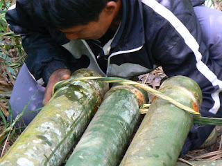
The walk wasn't so bad, we went up a thousand feet, Tui had phone coverage to talk to his friends, and we met a fellow who. with his sons. was up getting structural bamboo for building. I don't know how many different kinds of bamboo there are, twenty, fifty, a hundred, but not all varieties are used for the same thing. The kind these folks were getting was for the rafters and joists of a building. I suspect the woody part is thicker for this species. Remember from botany class, bamboo is a monocot, like grass. They brought only one tool with them, the big knife. They used the knife to cut the thick trunks and then went into the woods for a different bamboo which they flattened and fashioned into a rope, with which they tied the bamboo together and also made a simple harness for the long drag back to town.

Lashing the notched bamboo together using another smaller piece of split bamboo


The next day we did Tui's new one day "trek" over to the Akha village Long Pha Mai and up and behind the mountain Phou Pha Kahm. I'm not crazy over the word trek but that's what every one calls a walk in South East Asia so I will too. Normally the word trek conjures up images of multi month forced marches across sub zero arctic tundra combined with burning deserts and so on.
The heavy duty steel bridge that crosses the Nam Ma
 To start we walked down through old town with all the Tai Lue houses built using the traditional style, then across the suspension bridge and through the fields to the new bridge. The suspension bridge crosses the Nam Long, the heavy duty steel bridge crosses the Nam Ma, and shortly thereafter we walked through the Akha village. Tui pointed out how the Akha had adapted many of the construction techniques of the Tai Lue. It was true, but then these were dwellings built along the road with access to electricity and concrete. The portion of the walk before the Akha village is a pleasant stroll on flat ground through rice paddies and vegetable patches.
Naiban Ban Long Pha Mai


We stopped and talked to the headman for a while and he remarked on his recent surgery. He had some kind of stomach problem and had been losing lots of weight, the doctors in the hospital at Udomxai had cut into him and done something. It's well near impossible to figure out medical problems when talking to someone in Laos. Many medical conditions that are common vocabulary in our language have no words in Lao, and Lao people have no way to describe and no familiarity with the condition. Most ailments are simply described as what part of the body. In any case the headman showed us an impressive scar above his stomach and reported he'd gained back 7 kilos already, still looked thin to me, but seemed healthy and happy.
Naiban's kids, not the laughing or fooling around as usual but rather being carefully positioned and told to stand still and stop grinning like an idiot by mom and looked at by a buncha adults. Sister especially had a difficult time keeping a straight face.

The headman was happy to have me take a photo of him and his family and then he showed me the family photo that they recently bought. Some Vietnamese merchants were going to every village and selling large prints. What they would do is take photos of individuals faces, then photoshop them onto a picture they had of models in old style Vietnamese clothing. The end product is a large (11x14) high definition photo of an Akha family dressed like a royal Vietnamese family of 150 years ago. When I return to deliver my photos I'd hope they make up in authenticity what they lack in impressiveness, but I think it's a long shot.

The trail took off from behind the Akha village and quickly gained elevation. As soon as we slipped inside the forest sound seemed to quiet and the air was noticeably cooler and wetter. The fact that the trees were on the far side of the river and that there was rough terrain to get to them has protected them ever being cut. Big trees lay where they fell, turning into the dirt from which new trees grew as they had been doing since time began. Some of the big trees must have been at least a couple hundred or more years old, hard to imagine what life was like when they were saplings. Before this part of Asia was even colonized.
Tui and Somsai
It turns out this hike and the trail were Tui's latest creation for tourism in Muang Long. Many people come to a town and want to see some forests, a river, some ethnic villages, etc. and to sleep at their own hotels at night. The entire mountain of Pha Kham and gently sloping forest behind it have been made a municipal park.
Prohibited! Logging, Burning, Hunting, Littering

 Many local officials took the maiden hike and helped establish the trail and post the "no hunting" sign, which I think is mostly for our benefit. The hike does pass through uncut forest as soon as one leaves the village. I'd imagine it would be impossible to take such a hike from Luang Prabang, Luang Namtha, Muang Sing, Muang Ngoi, Nong Khiaw, or even Phongsali . There are simply no old forests so close to any of those towns.
Tui on log

The walk to the top of the hill was over quickly and we walked with ease through the very tall old growth forest around the back side of the hill and out to an overlook that seemed just above the town.
Muang Long with Phou Mon Lem behind

On the way down I ask Tui about the new vegetables I saw, and he explained the benefits of squash over melons, the price of rubber and how the valley was now making money exporting to the very close border of China. China will buy anything Muang Long can grow, except damaged melons. In no time we are fording the Nam Ma below town where the water isn't so deep and making the long trudge through the fields up to the road and then back to town.
The Nam Ma in the area of the ford below Muang Long

At my room I listen to the BBC on the short wave and took a leisurely cold shower carefully washing clothes and taping up my foot which had developed a blister. Thinking back on the day I realized Tui was right. It was indeed a nice hike. The trees were large and the forest was the tall kind you don't see often close to town.  Tui having a personal connection with the headman at Ban Long Pha Mai, made me feel less a gawker, more a visitor. Maybe 8 or so kilometers, five hours.

Homphan Guest House Phou Pha Kahm on skyline

ສມົຊາຍ

Key: Laos

the Communist Pathet Lao took control of Vientiane and ended a six-century-old monarchy. Initial closer ties to Vietnam and socialization were replaced with a gradual return to private enterprise, an easing of foreign investment laws, and admission into ASEAN in 1997. Laos Laos
Older Posts Home