Muang Long

Showing posts with label Muang Long. Show all posts
The area east of the Mekong, however, was soon wrenched back from Siam by the French Muang Long. the Communist Pathet Lao took control of Vientiane and ended a six-century-old monarchy. Initial closer ties to Vietnam and socialization were replaced with a gradual return to private enterprise, an easing of foreign investment laws, and admission into ASEAN in 1997.

The Trail to Nambo

Tui makes a last phone call while still within range of phone tower.


The trail to Nambo is a relative superhighway. It is by far the most gradual and fastest trail for hundreds of square miles. Using the cut of the the Nam Long through the mountains the trail steadily gains elevation while never resorting to switchbacks or steep sections. I've walked the trail twice, once back in 06 and more recently in the winter of 09. The trail provides easy access to the upper drainage of the Nam Fa. The trail is also used by all the Lao Sung as a quick access to the market at Muang Long. Bear in mind that tiny market is the biggest one in north western Laos beyond Muang Sing, and Burma across the river is even less traveled, it's a long way upriver to China or down to Thailand.


In 06 I saw the tracks of a single motorcycle made at the beginning of the dry season. I think it was a rider from that GT Riders club out of Chang Mai Thailand. They would of had to have pushed and drug the bike up and down many of the numerous stream crossings. None of the villages have motorcycles or other transport. I assume it was an off road bike, one of the last to have made the transect to Viengphouka. A few years ago there were temporary bridges strong enough to drive on with one of those one cylinder Chinese tractor things. The bridges were made by felling two large logs across the streams and covering the logs with branches and then mud and dirt. The logs have rotted away and are gone. Now there are small single slippery logs strong enough to support a person. I'd think it would more time and effort now to drag and carry a motorcycle up and down the many stream crossings than to just walk.
Stream Crossing

If you look on maps they show the trail as a full fledged road to Viengphouka, maybe it was in some one's imagination once, and it certainly might be at some future date, but for now it's falling back into forest. The dirt was hacked out of the hillside to make a flat graded path, and it was never wide enough for a two track even when new.
Google Earth-mountains beyond mountains beyond mountain
I don't know where the funding to work on upgrading the original trail came from. I've seen road crews making similar tracks. Fifty people hacking at the hillside with those heavy hoes they use to farm. Was this one of the many plans for crop substitution? A way to bring crops or forest products to market?

Tui from the tourism office asked me if I thought it was 20 kilometers. I guess so, I'm not the best at figuring kilometers, feels like ten miles anyway, maybe twelve or more. The road roughly follows the south side of the Nam Long but high above the river. I'm not sure of the elevation gain but it does go up all the way to Ban Nambo. There's a village somewhere, down by the river I suspect, I've never been there.

Stile


At the near end of the trail there are fences to keep cattle from wandering.. In English we call these fences "stiles". A person can walk up the ladder, an animal can't. The hillside drops off so steeply on both sides that the cattle are restricted to the road. As the kilometers pass under our feet most signs of people also pass. Soon we are beyond the distance that most people will reasonably walk to go hunting or gather stuff to sell at the market.


Bamboo in flower?

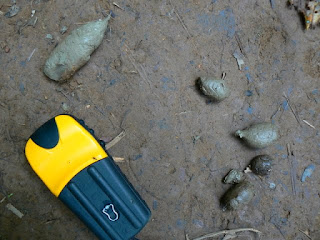
I stopped and looked at animal tracks, Tui thought them wild pig and large deer. People sometimes drive a cow or a pig in to town to sell for cash money, and the tracks might well have been from them, yet I hadn't seen any other tracks on the walk. In the forests around my house I recognise differences between the tracks of the deer, elk, moose, and domestic cow, in Laos not so much, even the cows are different. Guang yai (Sambar) are still around even if not as common as the smaller muntjak, and certainly wild pigs are plentiful. A carnivore scat had me guessing. There are two kinds of big cats and two canines, and two species of bear.


gps and carnivore scat


 Pig Droppings


I was sure it wasn't one of the two canines, too small, and not tapered at the end. The larger of the canines is called Ma Nhai as I remember (in Lowland Lao Language). I remembered it because of it's similarity to Ma Hai which is mad dog which of course I'd never use to describe a person, maybe I have it wrong anyway, and the peoples who live where the Ma Nhai lives speak other languages than Vientiane Lao so who knows what it's really called. We call it Dhol, and there is no love lost between the upland peoples and the dhol, not only because of the mutual competition for food.

Dhole from a camera trap by the WCS
The Dhol hunts in packs similar to our wolf, overwhelming it's quarry by sheer numbers and beginning their feasts by ripping out and eating the guts of the often still alive prey. Akha I talked to said they will bite people, no wonder they don't like the dhol. Bear droppings can vary, mostly I've seen bear scat when they are feeding on grubs, ants, and berries, or grass in the spring, this didn't look like either.


Clouded Leopard from the WCS
That leaves cat, which kind of goes with it's not twisted shape and no sign of vegetables. I've no way to tell the cats apart or even hazard a guess except that it had to be one big enough to eat deer. Immature tiger or leopard or clouded leopard?

Concrete Bridge. The most ambitious structur of the trail.
Past half way to Nambo is a landmark. A concrete bridge over the largest tributary to the Nam Long on the trail. We stop for a break and to eat the barbecued dove and sticky rice I bought in the market the night before. We eat the whole thing bones and all, I think Tui spit out the skull.

Well before dusk we begin to hear chickens and the trail once again is worn by the steps of many feet.

I hear children, smell smoke.

Through the trees, Nambo.
First Glimpse

One day treks in the vicinity of Muang Long (short longs)

Suspension Bridge over the Nam Long

I went to Muang Long to deliver some photos from my last visit and to take a get in shape walk for the walks I wished to do over the next couple of months.

Back home I'd been doing some jogging on the inclined treadmill at the gym and a lot of walking above 10,000 feet, but that was in the fall. The few week hiatus while traveling up from Bangkok through Southern Laos and Vientiane hadn't done me any good. I was still fat, old, and out of shape.

I knew that the trail up Phou Mon Lem is a calf pumping grind for a thousand feet, after that it tips back a little but still heads up continuously for another two thousand feet or so. I'd used this trail before, it's the most direct route to Ban Jakune Mai. I wanted to see if my legs were still up for the walk, and I wanted my guide Tui, to decide for himself what kind of shape I was in. Tui was less than enthusiastic about the hike, and kept recommending his new one day hike in the hills on the other side of the valley.
Tui maintaing a social life while on a walk


I was also trying to get used to the software on my new GPS. I bought the cheapest option from an old reliable company. The elevation function seemed pretty accurate but the part that tells one how far you have walked didn't work under the trees. Later I was to learn that the gadget could create a track of my route that I could zoom in on but it also used up the batteries.

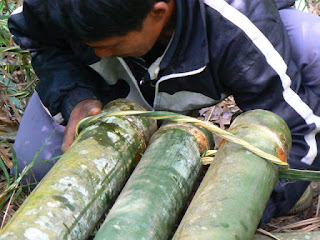
The walk wasn't so bad, we went up a thousand feet, Tui had phone coverage to talk to his friends, and we met a fellow who. with his sons. was up getting structural bamboo for building. I don't know how many different kinds of bamboo there are, twenty, fifty, a hundred, but not all varieties are used for the same thing. The kind these folks were getting was for the rafters and joists of a building. I suspect the woody part is thicker for this species. Remember from botany class, bamboo is a monocot, like grass. They brought only one tool with them, the big knife. They used the knife to cut the thick trunks and then went into the woods for a different bamboo which they flattened and fashioned into a rope, with which they tied the bamboo together and also made a simple harness for the long drag back to town.

Lashing the notched bamboo together using another smaller piece of split bamboo


The next day we did Tui's new one day "trek" over to the Akha village Long Pha Mai and up and behind the mountain Phou Pha Kahm. I'm not crazy over the word trek but that's what every one calls a walk in South East Asia so I will too. Normally the word trek conjures up images of multi month forced marches across sub zero arctic tundra combined with burning deserts and so on.
The heavy duty steel bridge that crosses the Nam Ma
 To start we walked down through old town with all the Tai Lue houses built using the traditional style, then across the suspension bridge and through the fields to the new bridge. The suspension bridge crosses the Nam Long, the heavy duty steel bridge crosses the Nam Ma, and shortly thereafter we walked through the Akha village. Tui pointed out how the Akha had adapted many of the construction techniques of the Tai Lue. It was true, but then these were dwellings built along the road with access to electricity and concrete. The portion of the walk before the Akha village is a pleasant stroll on flat ground through rice paddies and vegetable patches.
Naiban Ban Long Pha Mai


We stopped and talked to the headman for a while and he remarked on his recent surgery. He had some kind of stomach problem and had been losing lots of weight, the doctors in the hospital at Udomxai had cut into him and done something. It's well near impossible to figure out medical problems when talking to someone in Laos. Many medical conditions that are common vocabulary in our language have no words in Lao, and Lao people have no way to describe and no familiarity with the condition. Most ailments are simply described as what part of the body. In any case the headman showed us an impressive scar above his stomach and reported he'd gained back 7 kilos already, still looked thin to me, but seemed healthy and happy.
Naiban's kids, not the laughing or fooling around as usual but rather being carefully positioned and told to stand still and stop grinning like an idiot by mom and looked at by a buncha adults. Sister especially had a difficult time keeping a straight face.

The headman was happy to have me take a photo of him and his family and then he showed me the family photo that they recently bought. Some Vietnamese merchants were going to every village and selling large prints. What they would do is take photos of individuals faces, then photoshop them onto a picture they had of models in old style Vietnamese clothing. The end product is a large (11x14) high definition photo of an Akha family dressed like a royal Vietnamese family of 150 years ago. When I return to deliver my photos I'd hope they make up in authenticity what they lack in impressiveness, but I think it's a long shot.

The trail took off from behind the Akha village and quickly gained elevation. As soon as we slipped inside the forest sound seemed to quiet and the air was noticeably cooler and wetter. The fact that the trees were on the far side of the river and that there was rough terrain to get to them has protected them ever being cut. Big trees lay where they fell, turning into the dirt from which new trees grew as they had been doing since time began. Some of the big trees must have been at least a couple hundred or more years old, hard to imagine what life was like when they were saplings. Before this part of Asia was even colonized.
Tui and Somsai
It turns out this hike and the trail were Tui's latest creation for tourism in Muang Long. Many people come to a town and want to see some forests, a river, some ethnic villages, etc. and to sleep at their own hotels at night. The entire mountain of Pha Kham and gently sloping forest behind it have been made a municipal park.
Prohibited! Logging, Burning, Hunting, Littering

 Many local officials took the maiden hike and helped establish the trail and post the "no hunting" sign, which I think is mostly for our benefit. The hike does pass through uncut forest as soon as one leaves the village. I'd imagine it would be impossible to take such a hike from Luang Prabang, Luang Namtha, Muang Sing, Muang Ngoi, Nong Khiaw, or even Phongsali . There are simply no old forests so close to any of those towns.
Tui on log

The walk to the top of the hill was over quickly and we walked with ease through the very tall old growth forest around the back side of the hill and out to an overlook that seemed just above the town.
Muang Long with Phou Mon Lem behind

On the way down I ask Tui about the new vegetables I saw, and he explained the benefits of squash over melons, the price of rubber and how the valley was now making money exporting to the very close border of China. China will buy anything Muang Long can grow, except damaged melons. In no time we are fording the Nam Ma below town where the water isn't so deep and making the long trudge through the fields up to the road and then back to town.
The Nam Ma in the area of the ford below Muang Long

At my room I listen to the BBC on the short wave and took a leisurely cold shower carefully washing clothes and taping up my foot which had developed a blister. Thinking back on the day I realized Tui was right. It was indeed a nice hike. The trees were large and the forest was the tall kind you don't see often close to town.  Tui having a personal connection with the headman at Ban Long Pha Mai, made me feel less a gawker, more a visitor. Maybe 8 or so kilometers, five hours.

Homphan Guest House Phou Pha Kahm on skyline

ສມົຊາຍ

Long Time Traveler (Muang Long)


Muang Long. In the foreground Nam Ma (Ma River) with fields of melon and rice, in the background Phou Mon Lem (Mon Lem Mountain)

Up in Northern Laos in a long narrow valley lies a town far off the beaten track. It is the largest town in north west Laos past Muang Sing. To the north lie many small villages and many kilometers of hills before the Mekong and the border with China, south lies even higher mountains and a fast river with no bridges and no way to ford in the wet season. The name of the town is Long, it is the central town of the district so it is called Muang Long.

Map of downtown Muang Long showing Guest Houses, Restaurants etc


Muang Long is a market town, lying at the confluence of the Long and the Ma rivers about forty or so kilometers upstream from the smaller town of Xiengkok on the Mekong. Up the road to the east (17A) in the other direction is the old walled town and former opium market at Sing. The floodplain of the rivers is what gives Muang Long it's reason for being. The flat fertile fields along the bottom of the valley provide the agricultural base of the town. The road after it leaves town in both directions is dirt, and there are 4 major foot paths leading over the mountains.


"Long Time Traveller"


These fleeting charms of earth
Farewell, your springs of joy are dry
My soul now seeks another home
A brighter world on high

I'm a long time travelling here below
I'm a long time travelling away from home
I'm a long time travelling here below
To lay this body down

Farewell kind friends whose tender care
Has long engaged my love
Your fond embrace I now exchange
For better friends above

I'm a long time travelling here below
I'm a long time travelling away from home
I'm a long time travelling here below
To lay this body down...


I checked in to the Homephan guest house where I've always stayed, it's on the main road a block up from the market and is owned by the doctor who operates the local government hospital. When I say checked in I'm using the term liberally. They no longer keep a registry of foreign guests the way they are supposed to. Likewise the 6 bed clinic is hardly a hospital. What tourism traffic used to pass through Long has slowed to a trickle of late. The Homphan often has official guests from the government in the provincial capital or other districts. The rooms are clean if spartan, and there is a common area for sitting, the owner provides bottled water. I was the only foreign tourist in town.

In 2009 Muang Long looked very similar to the way I'd left it almost two years before, same bus station cum parking lot, cum town square. Same mountains, same rivers, same crag, same houses, same people in the market, same dogs sleeping in the middle of the street (Yes I know it's a cliche)
Homephan Guest House

As far as I can tell there isn't a hotel room with hot water to be had anywhere in Muang Long, , , yet. I'm writing this a year after I was last there, here's hoping, the cold season in the mountains up north can be, well, cold. Twenty four hour electricity has been around for a couple of years now but the use of it is still evolving. There are a few guest houses and a couple of restaurants. Don't expect English to be spoken anywhere

The most exciting daily event in Muang Long is the market. I used to drink coffee in my room and listen to my short wave radio. I'd know it was time to head to the market when I heard the sound of people walking and talking in the predawn half light. For breakfast I like to order a bowl of the local noodle soup called Kao Soi, at one of the many small Kao Soi stands set up around the market. I'm not a big fan of the fermented bean paste that tops the soup and makes it different from all the other regional noodle soups in northern Laos. The taste isn't objectionable or strong, I just prefer the plain noodles with broth, if they have a wedge of lime to squeeze over them all the better.


Dalat Long (Market at Muang Long)

Often at least one member of a family will go to the market in the morning, either to buy food or, if a farming family to sell some produce. The market is the social event of the day. People bring thier babies or come to gossip, some even come in their pajamas under a heavy coat. Most of the produce sellers are women and girls. Inside the market are those who can afford to pay the small rent to set up a table, outside on pieces of plastic or a small piece of cloth, sellers line up opposite each other so to form a long pathway for people arriving at the market to walk between. For many agricultural families selling produce offers the opportunity of some hard currency with wich to buy manufactured goods.

The people living in Long are Tai Lu. Lu are part of the same language group as Lao, Thai, Dai from Xipsongbana, etc. The language is similar to Thai or Lao but enough different that you have to speak it to understand it. Most townspeople are fluent in Lao also.

I've probably spent a dozen days in Muang Long. There is a large forest north and south of town, thousands of square kilometers in size. It is road less and has never been cut, the plants and trees and fauna are relatively untouched, I've gotten lost there three times. I call the area south of town The Nam Fa Drainage, it includes roughly the Nam Fa river and it's tributaries. The Nam Fa drainage is roadless for most of it's length before emptying into the Mekong, south of Xienkok. It is one of the last remaining intact river drainages in South East Asia.
Wat in old town w/satelite dish

 
Below the market and along the river is the old town with classic Lu architecture and a more relaxed feeling than up by the road. Trees are taller and the fields are closer, there's a wat. The Lu, of course, are Theravada Buddhists. Old town is nestled into the inside of a large bend in the Ma river. Across the river are many rice fields all the way to the crags of Phou Kam.

The Crags on the far side of the river

So Fa So Good


The Mekong just below Xienkok, the Nam Fa joins just out of the photo to the left

There is a steep sided valley tucked away in the mountains of Loas. It’s not on the way to anywhere. The river that flows through this valley crosses only one road far upstream and runs for 110 kilometres undisturbed until it empties into the Mekong unnoticed just below Xiengkok. Nature has also done her part to shield this valley from the covetous eyes of the modern world. Guarding both sides of the valley are steep mountains covered in thick forest, up and downstream powerful rapids make the river unavigatable by even the smallest open boat.

On the south bank of this valley on a sloped bench well above the reach of even the highest flood waters lies a tidy small village called Mongla.


Mongla..... I used the telephoto on my mini zoom to glass the town from 4km away, above Jakune. Large diptocarps rise above the canopy, tilled fields at higher elevations behind the village.

Mongla is not totally isolated. Fit and strong adults make a long one day walk to Muang Long or even Xienkok. They bring back manufactured items, such as lead for shot, fishhooks, gasoline for the generator, even tin for the roofs of the well off. But until recently the outside world had hardly made an impression on the remote valley and no one ventured in.


The Naiban of Mongla and a young boy who has been studying Laotian returning from Muang Long with fuel, a bucket, a woven mat, and some other manufactured goods. This is the ford below Jakune in the dry season. The flow is about ten cubic meters per second down by the Mekong, less than a tenth the volume of the wet season. Translation ; in August this river be rippin.

The people of this valley are Akha, the men can recite their lineage back to common ancestors with all the other Akha of Phongsali, Thailand, China, or wherever. They grow corn and rice above the river on the higher slopes of the mountains. For some reason they leave the trees and forests of the bottomlands uncut. Perhaps some sort of taboo reinforcing good conservation practices.

The trees are some of the tallest and oldest I’ve ever seen in Laos. Maybe it’s just the way they grow so close together amongst the large boulders. The trail is forced to climb up and over and around the roots of the trees in the perpetual twilight of the deep forest. Here the large predators and their prey survive in high numbers, not yet hunted for sale to the underground trade in tiger parts.

Tigers and leopards,
barking deer guar,
bears and civets,
slow loris sambar.


homemade muzzle loader it shoots a very small lead bullet with black powder

Fish eagle fly away,
Jakal can run.
What of the marten and badger,
For them it’s no fun.


Plants and vines growing on tree trunk

The other day bored and googling I came across this web site

Nam Fa Hydropower Project

I quickly scrolled through the article then slowly absorbed the map which is below.


When I enlarged the map all was fuzzy, still I remember enough of the river to recognise the basic lay of things. The Nam Fa trends west and joins a major tributary (Nam Kha) before joining the Mekong itself. I scrolled on back to the technical page. Max height 79 meters, ten kilometre access road. I could see the reservoir not quite reaching Vieng Phouka.

I already knew that many hydroelectric dams had been approved, on the Mekong, in Southern Laos, and a series of dams are planned to destroy almost all of the Nam Ou. I wasn’t surprised really but seing it in black and white really set me back on my heels. Knowing what the people looked like and having slept in their house and eaten their food didn’t help. They weren’t just any people.


Naiban Jakune


Naiban Mongla

Wife Naiban Mongla

Only in reading backwards to search for the start date and for particulars on where the access road would go did I realize the project had been discarded as not profitable enough. I hope it becomes less profitable as time goes by.


Nam Fa looking downstream from the ford below Jakune. After a short while the forest becomes very old and deep.

The following are the visits to the Valley that the Nam Fa runs through so far as I know.

At the beginning of the millennium Wildside Expeditions began to make an attempt to market the idea of a white water rafting trip to the area following their foray down the river on behalf of UNESCO and the Nam Ha Eco tourism folks. Writing in the advertising literature for a trip itinerary the writer, whom I assume must be Bill Tuffin of The Boat Landing Ecotourism Lodge, said, “ The Nam Fa offers one of the most pristine tropical river environments left on earth.”

The wildlife survey down the river by Wildside was the first known instance of outsiders entering the area. I don’t know if they were able to find any takers for their proposed 7 day raft trip. In 04 a mixed group of kayakers including Japanese and Lao nationals also paddled down the river. The rapids are rated at class IV, not too difficult for experienced kayakers, but not the kind of thing for the neophyte.

Beginning in the dry season of 06 Tui the manager of the tourism office in Muang Long started to take trekkers over the mountains on guided walks into the valley. He first took a pair of unknown hikers, then his friend Somjit took a very fast lone Scandinavian guy. Early in the dry season of 06/07 I hiked in with one of Tui’s students, Si Phan guiding me. Later in February 07 Tui hiked in for a second time with a trio of Italians. Even though the Italians were young fit twenty some things they didn’t reach Mongla on the second day until late in the evening. Just after that I too took my second hike, my guide this time was Somjit also his second walk into the valley.

I know that Sak the director of the agricultural department in Muang Long also hiked into Nambo and I assume Jakune as there were also public service health care type posters there. Probably he and Tui were assessing the viability of trekking in the area.

All in all six small groups of two or three people have headed into the valley of the Nam Fa, probably more by now.

I myself have entered or left by four different routes. The first time by cutting over to Nambo then down to Jakune. The river was still too high for crossing to Mongla and we hiked back up on the ridge to the north and tried to follow it down to Xiengkok. We got lost. Not lost lost, just couldn’t find a trail so we walked out to the road.

The first house we came to while headed for the road was perched on a steep side slope. The woman there seemed alone except for five or six dogs that were going wild barking and growling. At the time I thought that it must be a waste to feed so many dogs, now I realize why they kept so many, Asiatic Tiger.

The second time in we walked directly to Mongla due South of Muang Long by cutting over the crest of Phou Mon Lem and across the river below Jakune. We exited by crossing the Nam Fa a couple kilometres downstream of Mongla and regaing the ridge which we followed to Som Pan Yao and out to Xiengkok.


The bright wide blue lines are rivers, Nam Ma up top and Nam Fa below. The smaller darker blue lines are the various routes I walked in and out to the valley as best I remember and the red dots are also where I guess villages to be, from left to right, Som Pan Yao, Mongla, Jakune, and Nambo. Pink dots are abandoned villages one on ridge above Nam Ma valley and the other Jakune Gao.

A look at the map of the Nam Ha NBCA on the Boat Landing web site reveals lots of little animal profiles all over this area and many small house symbols indicating a village. You can easily see the tributary of the Nam Ma in Muang Long heading east and the proliferation of animal signs between it and the Nam Fa to the south. Someone went in there and spotted those animals or their tracks.

Map of the Nam Ha Protected Area on Boat Landing Web Site showing villages and animal locations

I know that Bill Tuffin worked in bringing health care to the area around Muang Long in the 90s, I would have to assume that he and others made perhaps quite a few trips in to the higher elevations and also down into the northern side of the river. Lots of animals are marked on his maps, and towns along both the tributary to the Nam Ma and the north side of the Nam Fa. I suspect many of the towns are now gone or moved. Nambo seems to be much closer to Vieng Phouka than I thought.. And I know one of the village symbols must be the recently abandoned Jakune Gao.

At least three large villages that I know of have moved either to another location or out to the road since this map was made. I covered a small portion of this area, there must be many more relocated ban nock.

The map from The Boat Landing has been invaluable in trying to make sense of where things are. I also cross reference between Google Earth and my old topos that date back to the war. It’s hard trying to remember the lay of the land from some walks I took a year ago. Especially as I was walking as fast as I could just to keep up. But then I am supposed to be able to keep my sense of direction while covering long distances off the trail, it‘s my background. It’s gratifying to see the three sources of information seeming to match my memory. The more I look at the maps and try to remember the shape of the hills, the more the maps and my memories seem to coalesce into a series of overlays in my minds eye with some points in common to all.

The distances between villages is prohibitively far. I don’t see how they can run treks in this area without some places to sleep halfway between the villages. One way or another more and more trips will be made into the valley that surrounds the Nam Fa. My only wish is that future walkers can also see those ancient trees with the wide buttressed trunks, and a wild river not yet dammed.


Ban Nambo

Adrift on the River (or why make clay figurines)


Looking North from Boyee Sang Mai.

After fifty miles or so there is the place where the Nam Ou curves back to the west, then after another long way it goes to the border of China, then after who knows how far there is a road.


Ban Wa Tai

Above is a photo of the Nam Ou in Ban Wa Tai above Hat Sa. The river is quieter up here, it sees a lot less traffic, everyone headed for Phongsali jumps out at Hat Sa. At the time I took this photo I was very happy to be headed downstream, in retrospect I should have been headed up, ever further up the river as Kurtz would have it. I was on the last day of a 5 day walk in the mountains drained by the Nam Ngam, Nam Long, and Nam Ngay, the last of which I had been crossing back and forth the day before. The thought of hot showers and clean sheets filled my mind. I was also looking forward to Chinese food and fresh coffee at the Phongsali Hotel.

How quickly we grow to miss our creature comforts. A few days in some windy hills and I go rushing back to the relative comforts of a remote Lao provincial capital. I had been spending the nights on the ridges, so it was nice and warm to be in a valley.

The Nam Ou I was leaving winds many miles upstream without a guest house, English language menu, or bus schedule in sight. Also no roads or cars or busses. Electricity, what there is of it, is by small generator. The river first heads north through the Phou Den Din NBCA a place I’ve never heard anyone talk about. It’s not as if the Den Din NBCA backs up against any population centres either, just Lai Chau province Vietnam. After the Ou leaves the Conservation Area it curves west and then north again to Ou Tai then straight north another hundred or so kilometres to Bosao and the border with China. China just stretches on and on forever with even bigger mountains and valleys and more mountains that no one has ever heard of. It’s Yunnan province, without the hype.

I should have turned around and headed on upstream. There are boats, it is a river, I can communicate after a fashion. Heck I can even talk more easily to the folks in Ou Tai than in Phongsali. Ou Tai people are Thai Lu. I should say most the townspeople are Thai Lu, I saw plenty of ethnics I didn’t recognise. Phongsali people are Phou Noi. Pasa Thai Lu is plenty close enough to Lao or Thai, Pasa Phou Noi is like no language I’ve ever learned to howdy in.

I started out this posting thinking about Thai Lu, and Thai Lu culture, (more later), my thoughts just kind of drifted on up to Ou Tai. I’m fascinated by the town. I know some other people that have been there, but I don't know anyone who has gone for a walk. A police man and a career army guy (party members?) offered to take me around, but by the time I got there I just wanted to go home and hang out with my wife and kids. It was the end of a trip not the beginning.


Crags across the river Ma, Muang Long

What started me thinking about the Thai Lu was I found some notes I took from my second trip north last winter. The notes were about a kind of religious offering I wandered into while going for a walk outside of Muang Long, another Thai Lu town, on the other side of northern Laos, over by the Mekong.

I had to kill a day while waiting to go for a guided walk, so I walked across the river to the crag. I crossed the Nam Ma and then a narrow, but almost deep enough, tributary. I was happy to keep my flip flops from being washed away. I wanted to get a view of the good sized hill above town I would be walking up the next day, and also I just wanted to get out of town for a while.


The Raft

There was an irrigation ditch close up alongside the crag and I found the little woven mat below with the figurine made of clay. I knew immediately that I was looking at some kind of folk religion type thing. I was unsure how it had gotten there. Surely it couldn’t have floated down the irrigation ditch. The woven matt looked like a small raft and the woven horse with rider and figures made of clay had been carefully crafted. It seemed as if the clay figure even had a bed or blanket to lie on.


Are we too originaly of clay.

I of course touched nothing but saw no harm in taking a photo. I have my eyes open when walking and hadn’t seen anyone. When I got back to town I showed Tdui, the tourism official, my photos. He was very excited to see what I’d found, and explained that when someone is sick or has troubles they make the figures and the raft as I call it, to draw away the bad spirits. A shaman is consulted and he says words and tells them where to leave the raft. The figures are kind of sacrifices to the bad spirits.


Update 6/16/07
laomeow asked some Thai Lu monks she knows. They confirmed that the figurines are used to draw away bad spirits. The name for the figurines is “Sataong”
I believe the “transferring” of bad spirits away from oneself into the body of a third thing is a common theme throughout cultures.

Second Trek into the Nam Fa Watershed


Mongla (probably old landing site LS358) as seen from below Jakune

After my Green Discovery trek I still had energy and the ambition for more. I called Tdooee but his cell phone wasn’t yet within range of a tower, as I suspected he was still trekking. When I got through the next day he said come on over.

As usual with Tdooee things were still up in the air when I arrived. He knew and I knew that he was by far the best guide in Muang Long. Not only is Tdooee the only person who speaks Akha with any degree of fluency but he is also clued in to the traditions and habits of the people which is one of the things I’m very interested in while trekking. The sticking point was his brothers upcoming wedding on Saturday. Tdooee likes to party. He sings in the band, drinks whiskey daily and is still at that magical age of mid twenties when having a good time is pretty important. It was obvious he couldn’t miss his own brothers wedding.
Tdooee pretending to work

The next day at eight in the morning when we were to leave there was a delay for a day. Somjit my guide had other duties to take care of, who knows. Tdooee offered alternatively to take me with the Europeans for a guided gawk at a Lanten village just down the road.

From the moment we got out of the minivan you could tell this type of thing wasn’t unusual for the village. The kids gathered around but there was no begging, perhaps because they were Lanten, maybe they had been taught that this wasn’t the thing to do. While we were there another minivan stopped with three foreigners to also gawk. At first appearances such a visit might seem like the typical stop and take pictures as in a zoo type thing. Having a guide knowledgeable about the village changes your perspective.

Euro Jester

We walked up the street and stopped to look at a loom where someone was weaving. One of the Europeans who works as a jester at renaissance re-enactments gave a juggling and mime show. A lot of people gathered around to watch and laugh. It’s a common enough occurrence where you are a stranger and kids are curious and amused. I’ve seen foreigners doing some pretty stupid things for kids, god knows what the kids think, I know they aren‘t laughing with. I was less put off than usual as at least this time the entertainer was doing something that he also does in the west. My goal when visiting a hill tribe village isn’t to be the focus of attention however flattering it might seem, but rather to be a quiet observer.

After a few minuets we continued our stroll up the street and I learned some things well worth the drive. I’d heard the name Lanten before but knew nothing about the people. The following is as I remember.

The Lanten have a written language similar to Chinese or Japanese. Most hill tribes I’d encountered had none. They made paper using bamboo shoots and lime. They weave their tongs (the hill tribe over the shoulder bag) in a distinctive striped pattern. They had a nice forge made using the charcoal that many use to make fires in Vientiane and also a bellows made from a large piece of bamboo and a plunger type piece of wood. The Lanten seemed a more settled community than say the Hmong or Akha.
Lanten Forge

Tdooee of course knew the headman and we stopped at his house for a chat. I liked the attitude of the Europeans while at the headman’s house, respectful without fawning, and curious as to what the relationships were between all the members of the family. While there the supervisor for the crew putting in electric poles came by marking the places to put the poles. I don’t need to say that electricity coming to Muang Long and all of the small villages in the area is a big deal.

There is no full time trekking program in Muang Long, just a very few guys with basic English skills and the willingness to go for a walk. Altogether there have only been five treks Into the large road less area East of Muang Long. Technically not within the Namha Protected Area it is still encircled by the same roads. To the west and north the road running from Muang Sing to the Mekong, and to the south and east the road running from Luang Namtha to Huay Xia. The area drains with the Nam Fa, not the Nam Ma and it’s fairly remote for being so close. I’m always amazed at how far removed one can get from a lot of things by just walking a few hours away from the road.

Tdooee took the first walk back there with at least two trekkers in 04 or 05. Somjit who was my guide for this trek took a lone 18 year old Dutch guy back there for a very quick hike in November of last year. Then I took my trek with Sii Phan when we got lost in December, and Tdooee took his second walk with three young Europeans just before I arrived. My trek was to be the fifth. Tdooee, Somjit, and myself have all been there twice now.

Me and Tree

A quick conversation with a couple of guys headed to the village that was our destination for the first night revealed an eight hours for hill tribe people type walk. For reference Green Discovery seems to double a local persons time, in Pongsali we were probably adding one hour for every two and a half, but then we were hiking pretty quickly. My guide Somjit spoke almost no Akha and all conversations were in Lao, so I could eavesdrop somewhat. No one can match hill tribe times. I like to trek to watch and learn not as a hiking marathon. Plenty of big hills where I come from in Colorado.

Seeing as we had quite some elevation to gain I figured we would be lucky to arrive half way through the night. I had a bag and ground cloth adequate for a night out but the guide didn’t. In looking at the map now I can see we had over 4 thousand feet to gain and the same amount of descent. I’d looked at the mountain from a distance across the valley the day before to get an idea of what was involved and I knew it was a good sized hill. I didn’t like starting off a trek knowing that we’d bitten off more than I could chew, especially since I’d gone on two established treks recently, one with a government tour office and one with the biggest private operator in the country. I know things don’t have to be that hard.


Phou Mon Lem, we crossed the ridge just right of the summit.

A bad attitude doesn’t do anyone any good. I decided to just see what would happen. Worst case I was still going to get a decent nights sleep even if it was a little cold. It was either that or turn around right then.

I recently bought a hooded fleece jacket that has no zipper in front and is very roomy. They custom made it up the road from where I’m staying in Vientiane for three dollars. For another four dollars they sewed a small bag out of the same piece of fleece that comes about to my armpits. The two together along with my reflective ground cloth give me the ability to get at least some sleep even on a pretty cold night out.

I also carried 3 litres of water, a change of cloths, a pair of flip flops in case my running shoes gave out, a headlamp, four pair of good socks, a kitchen knife, my reading glasses, ten single portion packages of instant coffee, (my drug) and four packages of instant noodles. A small Gore-Tex rain coat was my back up stay warm and dry when all else fails piece of gear. Also my camera.

I’d caught Tdooee making a little sketch map for Somjit the afternoon before, so I was aware that despite Tdooee’s assurances that Somjit had covered this ground before, there were unknown factors. Turns out Somjit hadn’t been up this particular trail before until it joined the regular one at Jakune Gow. What we were doing was taking a short cut directly to the point in my last trek where we had started to go wrong, visiting a new village that Tdooee had recently stayed at and finally exiting via Som Pah Yow and walking in to Xiengkok as planned a couple of months ago. The direct trail to our mid trek point of before was quite a hike.

Mongla house with expensive roof, our first night’s destination.

Somjit easily out hiked me and we traded packs. I don’t like someone else carrying my pack when we aren’t even in trouble yet but he only had one litre of water and a machete. I swallowed my pride and concentrated on walking up the hill. The old trail stayed to the top of the ridge. Overcast skies, cool temperatures and a stiff breeze made the uphill slog a lot easier. I’ve gotten stronger over the past four months and we made good time.
The forests we were walking in were all old growth for the entire trek except where there had been slash and burn. Typical of treks in Muang Long it had more resemblance to a forced march due to the distance between villages. Until there are huts built mid way to sleep in, that’s how it’s going to be. Undoubtedly some days are twenty kilometres or more. Not much time for examining plants or identifying trees. Hill tribe villages are a place where you don’t have to walk for a few hours. The upside is a window into a place and time that in another half a breath will be gone, with no more like it.
The hill tribes aren’t primitives. They have a language and a culture that is unique to each one. They work metal, they have frame houses. They are aware that there is a great big world out there, many have contacts across national boundaries within the clan group. They like electricity and tin roofs on their houses, who wouldn’t. Besides the little compact fluorescent light bulbs some also have DVD players which they power up the generators and use precious gasoline to run. Thai music videos are an essential part of life even if they don’t understand the words.

We were walking directly up the highest point around called Phou Mon Lem in Lao which means hay mountain in English. The top of the hill is unforested and always grows hay. In no way do the mountains of Laos even come close to tree line, I’d hesitate to even call them mountains, no glaciers or snowfall of any kind. They remind me of the Adirondacks or the Green Mountains in the north eastern US. They are steep. Without being cliffs they are some of the steepest things covered by dirt that I’ve ever seen. Not much chance for erosion to have it’s way, they are typically covered with some sort of plant. Often when you kick a rock off the side of the trail it keeps on rolling.

Click here for the map to the area

Find Muang Long by moving the map to the upper left. Phou Mon Lem is marked 1751. Our walk took us just west of the top of the hill, from there we walked side hill and down (southeast) to our village for the night, Mongla, which is probably at about the same place marked by the red dot LS358. An extremely old helicopter landing site from the war.
From Mongla we walked the south bank of the river half way to the bend, then re crossed to the north side, and crossed the tributary before heading up the old trail to what is marked Ban Kou. Our route actually walked along the back side of this hill a short ways to Ban Som Pan Yao. Ban Tdaw Sum was further along this ridge at the top of the second to last spur headed down to Xiengkok. The spur we followed to Xiengkok points right towards the letter “a” in Nam None. This is the site of Xiengkok old town.
Click here to see the adjacent map for reference
On any map of Laos you can see the sharp bend in the Mekong where it says “Shan State” you can even see Xieng Kok (Xiankok) written in. That big sharp bend is most of the way up the left side of Laos along the Burma border below China. The hill labeled 1156 is on both maps due to the overlap. 1156 is where we walked down towards Xiangkok from. 1156 is also the approximate location of Ban Tdaw Sum.

The trails themselves are old, often I suspect very old. I’ve noticed them cutting deeply into the dirt on the tops of hills. Villages seem to move, I’ve never seen one that was in it’s present location more than thirty years ago, but I’d wager the trails have been used ever since these hills had people.
Before the top of Phou Mon Lem we were joined by a middle aged friendly guy and a ten or twelve year old boy. The man was carrying four litres of petrol for the generator, and the boy was carrying one litre in an old bottle and a new sleeping matt. They had left Muang Long forty five minuets later than us and caught up by noon. They remained with us for the rest of the day. We had the same destination.
As soon as we began heading downhill I took back my pack and kept it except for a short stretch the next day. We paused for lunch at the first drinkable water on the downhill side of the hill. Both the hill tribe folks and Somjit drank from the small stream. I carry all my water to avoid drinking surface water if possible. I’m scared of all the parasites, from animals and humans. Last time here I drank from the streams of necessity. When I got home I took a three day course of worm pills, better safe than sorry. Three litres is just enough to allow me ten hours of strenuous exercise. We all shared lunch but I ate very sparingly. No energy to waste digesting food.
After lunch I continued to go as fast as I could. Until we hit the trail junction at Jakune Old town we were on trails that neither Somjit nor I had been on before. We were worried about how long it might take. After an hour or so we stumbled down to the trail junction. I looked at the very faint path we had followed to get lost last trek and marvelled that we had even taken such an unused trail.
Jakune Gao was the first abandoned town from my last trek to the area. We didn’t even break for a rest.
At Jakune Mai, (Jakune New Town) I walked directly to the Naibans house where I had stayed last time. Tdooee had said that he found the people of Jakune Mai not friendly. That hadn’t been my experience and I owed them a thank you for putting me up. When I’d been there before things hadn’t dried out yet, and I was still in pretty poor shape. My spoken Lao had been a lot worse. The Naiban’s wife’s had given me a massage and they’d even brought a basin of water for me to wash my legs and feet which were extremely muddy, before I slept on their clean blankets.

Naiban Jakune, yes I know I have to photo shop out the poster next to him left and right.

I figure all these villages that are a long ways off the road are still growing opium. Tdooee represents the government, his dad is a Naiban and war veteran. Probably the villagers don’t like people nosing around what is now an illegal crop. I could care less what they are growing. Opium has been the traditional cash crop for as long as anyone remembers. The soil is poor. For a people who know nothing of modern medicine it is also a lot less painful way to die of sickness. The average life span has lengthened with the decrease in malaria but I think for most life lasts maybe forty or fifty years.
The two pictures I’d sent via Tdooee had been given pride of place being tacked to the outside wall of the Naiban’s house next to the door for all to see. They are the only photos of anyone in the village. When I arrived the Naiban was shirtless and wearing the traditional hand woven baggy trousers that hill tribe men wear. His head was completely shaved except for a wisp of a topknot sticking out of the top of his head. He kind of looked like something out of a Chinese Gangster movie. Knowing more about things now I immediately asked to take his picture and promised I would somehow see that it got into his hands. Unfortunately the Naiban donned his hat and jacket for the photo. You have to remember the photo is for him not for us.
I spoke directly to the Naiban, not through an interpreter, remaining off his porch so to place myself below him. What I said was mostly about how indebted I felt over his hospitality for the last visit and that I had brought some small gifts that were very meagre but I wanted to show my appreciation somehow for putting me up last time. I’d brought him some aspirin type stuff, disinfectant for cuts, throat lozenges for soar throats, sterile cotton swabs, and some spices that I thought his wives would like. Chicken soup base, whole black peppers, shampoo, and of course a couple bags of bang nua. The medical supplies were at the suggestion of the government doctor for the area. I took a pass on the other medicines I didn’t understand, I was afraid they were antibiotics which everyone takes for the wrong reasons and in the wrong doses.


Good Sized Hill below Viongphuka as seen from Jakune

The Naiban again invited me to stay at his house but I declined saying the tourism office had made plans for me to stay at Mongla. We hurried out of town, we still had a river crossing and unknown hours of walking in front of us. I saw our local guide from the last trip also at the headman’s house, I think he is a sort of advisor. Also on the way out we saw the Shaman.
Our walking companion hadn’t accompanied us to the headman’s house and we quickly made our way downhill to the river. Waiting at the river were some young teenage boys. Soon after we took of our shoes to cross our companions from earlier in the day joined us. They had missed our exit from the village.


Young teens by the river

The Nam Fa was never deeper than mid thigh where we crossed, but the water was quick and there was a fair amount of volume. It’s easy to see how this might have been impassable in December when things were wetter. On the other side the middle aged man took off all his clothes and rinsed off. The boy retained his underwear and went for a swim. I too took off all my clothes and dove in, on the way out I wiggled for the teenagers watching on the other side. The bath felt good.

Crossing the Nam Fa

The remaining miles to Ban Mongla seemed to go quickly through the very old forest close to the river. The trees were larger than I’d seen before on this side of the Namha Protected Area. As we walked through the beginning of the village my guide asked the middle aged man we had been traveling with for the day how to get to the Naiban’s house. The man replied “follow me, I am the Naiban”.
The Naiban had recently married his second wife. I thought she was a friend of his wife’s. I caught on as he started explaining how there were too few husbands in the village and some of the men had needed to take second wives. Right. I’ll try that on my wife. Actually the two wives seemed to get along very well. I wouldn’t be surprised if the older wife had a lot to do with choosing the second one.

Second Wife of Naiban Mongla

As I started to jot down my notes in my notebook his youngest son came over to watch and I showed him my sons picture. They are about the same age. The son called the Naiban over to take a look and he also looked at my other two pictures, one of the kids and my wife posing in the water at the beach and another of my wife kissing our daughter and smelling her neck. Babies smell nice. The Naiban looked at the kissing picture a long time even though you can’t see anyone’s face. I think everyone in the world loves kids, especially babies.
The next morning while out on the porch the Naiban and his second wife eagerly posed for photos. Being the most important personages in the village it makes a lot of sense. A lot more than photos of kids or chickens.

Naiban Mongla

Dinner consisted of one very thin chicken, I mixed the soup with the left over sticky rice and ate a lot. Other people waiting devoured the remainder of the chicken stew quickly. Not much food in the village. Dinner had taken a long time to get together also. My guide Somjit was only twenty three or four and reticent in the presence of important peoples. My instant noodles were the only breakfast which is fine by me. For lunch Somjit took left over mountain rice from the night before and left over barbequed duck from the day before.
We left at eight, not as early as I’d like but better than most treks. After an hour along the river we crossed it, on the other side we chatted to two men carrying two gallons of homemade whiskey and headed in to Muang Long. They quoted a regular time to our destination of four hours.
When we started walking again it was with a feeling of the pressure being off. The day before we had done eight hours in nine and a half. We hadn’t taken breaks except fifteen minuets for lunch and we’d moved as quickly as possible. A four hour walk shouldn’t take us longer than six I reasoned. Somjit wasn’t so sure, he remembered having a hard time when he had walked this trail before. It did go up. The grade was more like I am used to in Colorado, uphill without fooling around. The two men from the village were in great shape and when I stepped around them to get in the back they quickly left us.

I had at first thought the guys were carrying gasoline for a generator, same type bottle as yesterday. When Somjit explained they were off to sell whiskey in town I asked more questions. How much do they sell a litre of whiskey for? One dollar US. Why would someone go to Xiengkok to take the tuk tuk to Muang Long to sell whiskey for less than the cost of the ride? No answer. Xiengkok is kind of a wild east town. Remote border crossing to the refineries in Burma, access to the Mekong and therefore the rest of the world via shipping containers from China. The mind is just chock a block full of possibilities.
We hit the approximate top of the hill a little after noon. We had been taking breaks, not long ones but breaks. Somjit pointed towards the horizon and said he could just see Som Pan Yao. When I asked him to describe where, he had a difficult time. When I tried to nail him down it turns out he was referring to the reflection off a roof a long ways away. His memory of places was very sketchy. I think he was following the trail but paying little attention to which side of the hill or drainage he was on. In short even though he came from a farm in Muang Long he was more of an in town guy than a mountain kid. He had spent a long time going to college in Luang Nam Tha. He also walked with feet slightly splayed, not such a great indicator of someone who had walked a lot.

We needed to walk behind the left of the three bumps to get to our place for the night.

The prospects had shifted again. I knew that it was a long way to the reflection of the roof no matter how many hours the hill tribe guys said it took. Also Somjit was low on water. The tributary we had crossed at mid morning was a little large to drink out of safely. Again we walked in a hurry. Four long hours later we came to a spring that was fine for drinking. An hour later we entered Som Pan Yao which had a road to it.
Having a road always changes the character or a village, or maybe it’s just my perception. Thankfully Som Pan Yao was on the nearer side of the mountain from where Somjit thought. The trail also had traversed the back side instead of following the top. The Naiban wasn’t home but was up watching the cutting of the posts for the new schoolhouse. To cut the posts he had contracted out to someone with a chain saw from Muang Long, Thai Lu people. We could hear them doing the rip cuts as we came into town.
While we waited for the Naiban to return we ate the rice we’d taken for lunch dry. We also had the old piece of barbequed duck but I was afraid it was too old what with all the hot weather and all. It was at least 30 hours without refrigeration. When the Naiban finally returned at around dark with all the men that had come to cut the wood it was a little late for cooking. Somjit reported there was no food to buy in the village.
The woodcutters had food from somewhere and ate with an appetite. After they were done they started to amuse themselves with the foreigner. They started by giving me a “sabai dee OK” with the thumbs up signal. This is supposed to be some sort of foreigners talk. It’s what everyone says to the foreigners in these parts especialy after they're in their cups. I replied that yes indeed I was sabai and they could go ahead and speak Lao as I’d been following their conversation throughout dinner. Silence. Some nervous laughs then some questions. Where did I come from, how long had I been in Laos, and all the usual ones. Then I got one I’ve been waiting a while to hear. ”Why do you come to these small villages, what interests you here?“ My answer was only partially true. I said that until very recently my family and all families in the world had lived much the way the people of Mongla did, and that now almost no one lived that way, I want to see these things before they are gone forever. Unstated was also my interest in the great variety of species existent in the old growth forests. I also like walking.

Naiban’s Second Wife Again

I lay down after a while intending to eventually drift off to sleep. Somjit roused me with the announcement that he had cooked some food. Fine by me. I sat down to chicken stew again with the Naiban and Somjit. The Naiban lifted out the gizzard, liver, and intestines, and dropped them in my cup. I was appreciative, best parts. The woodcutters took off with the announcement that they were going to find some girls. I asked them to bring one back for me.
As I once again drifted off towards sleep the woodcutters returned with a few drunk girls that were of an age that even I thought was young. Thankfully none for me. We were all sleeping in the mens room. Akha houses are divided between men and women, this house had separate rooms for sleeping by gender. Our room was about five by six meters. The girls sounded like they were intent on getting drunk and getting laid, I wondered how all this was going to occur with such a lack of privacy. Thankfully I once again drifted off and so missed the details. I had to ask Somjit how it all went in the morning. I hope they looked upon my deep snores as mood music.
After three months of it I’m fairly used to sleeping shoulder to shoulder with a bunch of Akha people but this was a new one on me. When you think about it they do have children, and they sleep communally. Of course all the wood cutters were middle aged married men Thai Lu men. As for the Akha girls I think the Akha are allowed promiscuity before marriage.
A long time ago I had an Akha friend in Chang Mai. He was a trekking guide and I would hear him regaling the backpackers about the sexual practices of the Akha. Mostly I ignored it, he was always joking around especially to get people to sign up for treks. I wish I’d listened more closely, I think he was telling mostly the truth.
Ten years ago he was doing time in Chang Rai for heroin, I wonder if he’s even still alive. A big job hazard of being a trekking guide is becoming addicted to opiates. Many of the tourists want to try smoking opium and the trekking guide being the jolly fellows they are of course join in. A few years later the tourist has moved on to life in the corporate world back home and the guide is still taking people trekking and smoking opium. If you have a habit, heroin is a lot easier to do in the city where the smell of opium would be dangerous.
The Lao government is trying to avoid these pitfalls by tightly regulating it’s trekking industry. They have studied what happened in Thailand closely. I myself am ambivalent about opium and it’s use. Like any drug I guess it’s best avoided. I only wish there were such a stigma attached to alcohol and tobacco consumption the two biggest killers by far. The drinking of hard liquor in Laos in such quantities is new. With so many making so much money now the untaxed moonshine is within everyone’s budget. Labelled, factory made, lao lao sells for half a dollar for a half litre. Cigarettes are twenty cents a pack. Seems like ten years ago I never saw people smoking.

Lao Lao and banana flowers on sale Muang Sing

The next morning we took off walking down the road. I’m usually not big on walking down roads, better to ride. After a half hour we cadged a ride for a couple miles off a motorcyclist, the only thing that passed us. At the town of Muang Kan we turned off the road and onto a path, the old trail to Xiengkok.
I haven’t talked about the trees and terrain or animals that we were passing through. There was no time to talk as we were walking. Unlike Green Discovery this trek was about getting to the town of our destinations. I also don’t think Somjit had an extensive back ground with hill tribes or the forest. I had been telling him a lot of the traditions and culture that I had learned from the Green Discovery guide, and it seemed like it was new to him. Everyone knows that you don’t walk through the gate to a village. Not many know what the carvings and symbols are for on top of the gate, or why it is moved out but never in. Likewise it takes a long time to learn a few of the different trees and their uses, or to recognise all of the signs of animals.

The gates when leaving Mongla

The area we were in was the next drainage south from the Nam Ma, the river is spelled Nam Pha on the topo map but I call it Nam Fa, seems simpler, the ph sound is a Vietnamese spelling.
The trail down to Xiengkok was surprisingly pretty. It took four hours and much of it was through original forest cover. From the ridge we were following down off the mountain I could look across and see a fair sized Akha villages sitting on the last ridge off our mountain, called Ban Tdaw Sum. It’s getting so I feel as if Akha villages have a certain look about them even from a distance.
Somjit and I had always been more evenly matched on the downhill, I had gravity helping me out. Now he began to drag. He was wearing shoes for maybe the first time. Fake Converse All Stars. His toenails were digging into his toes. I gave him my flip flops to wear much to his relief.

The Mekong from above

Soon before Xiengkok we spotted the Mekong headed for Thailand below us. I for one was happy to see it. Old Xiengkok is a kilometre down the road before the new town which all are familiar with on the river. I sat there at Somjit’s grandmothers house and waited for him to rustle us up a ride. Forty five minuets later he brought the borrowed motorcycle back announcing there were no rides and we might have to stay in Xiengkok. I didn’t believe and offered to go take a look myself. He came and gave me a ride on the motorcycle before I’d walked too far.
I’m not shy to talk to people. I know that all we needed was something that would move and someone who wanted to earn the ten dollars of whatever it took to get to Muang Long. Of course there is no telephone so I couldn’t call Muang Long and ask them to send a minivan. I felt sheapish approaching groups of middle aged men who were slowly drinking beers on a hot Saturday afternoon and calling the oldest one uncle enquiring about renting anything that moved to get to Muang Long, all this while a fluent Lao speaker is waiting on his bike. Of course soon I struck pay dirt, a guy started walking around with us looking and he found us a ride on a truck carrying bricks. Somjit warmed to the task also once he learned that you don’t only have to look for the usual transportation.

Fast Boat headed down towards Thailand out of Xiengkok

After arranging to get on the truck after they had filled it with river sand I took Somjit and the guy who had helped us to the restaurant across the street and I sprung for a lunch. The only soup on the menu was Tom Yum so I ordered us up three bowls. It was surprisingly good. Thai food. Looking around the restaurant I wondered to Somjit how such a place could stay in business. There were maybe three of four foreigners a night in Xiengkok, maybe being the important part. Probably none, certainly not enough to support the number of restaurants there. Then Somjit referred to a girl walking down the street in Lao Language as a night worker. I asked what he meant. I’m more familiar with the term “Sao kai beeya” (girl who sells beer) or less politely “galee” which I won’t even say in English.
Suddenly I got it. But where from the customers? Somjit said mostly Luang Namtha. Seems like quite a ways to go to buy girls I thought. Just another facet of Lao culture I’m fairly ignorant about. Xiengkok in general seems like a sleepy little town where it’s probably better not to wonder what people are up to. Whether someone is there for business or pleasure best not to guess what business, what pleasure.

Xiengkok Restaurant

Tdooee’s brother’s wedding party was in full swing when we got back to Muang Long at around five, the only restaurant in town was also closed. The market was out of rice and of course meat, I grabbed some cooked sausage and a big bag of sompac the pickled mustard greens made with rice water, one of the vendors went into her shack and grabbed me a cold chunk of sticky rice out of her pot. I hadn’t eaten much over the past few days and was hungry. In my room I took a cold shower, the only kind there is in Muang Long and washed every piece of clothing I had with me. At six thirty the generator kicked on and there were lights and a fan.
The truck to Luang Namtha left at 9:30 and was fairly uneventful except for the problems with the brakes. The road to Muang Sing is unpaved and one hardly needs brakes. The hard surface to Luang Namtha is another matter. The brakes were way past soft, the driver would pump till his leg fell off. He bled them and bled them without seeming to have much luck. We stopped up the road out of town again to try to bleed them. At the police checkpoint fifteen or so kilometres out of Muang Sing, the whole truck got the going over. Everybody out while they check us and the bags. They slit right into the rice sacks and felt around then closed them up with cellophane tape. A big truck full of rice in front of us was being re stacked so that they could stick a metal rod into every sack. I think they were more interested in meth coming out of Burma than heroin or opium. Who knows, guns? TVs? I wouldn’t think anyone smuggles opiates into Laos. It would be like bringing maple syrup to Vermont.

Bleeding the brakes at the Wat just out of Muang Sing

After messing with the brakes one more time we all got back on. Then they put some poor Chinese fellow in the back and handcuffed his hands to the frame of the truck. Illegal immigrant. A lot come over from Boten. We dropped him off at immigration in Luang Namtha where they had a key that fit his cuffs. Rather him than me. Looked like a well dressed studious kind of guy, I’ve heard they beat them pretty well on their return to China.
As I left Muang Long Tdooee asked how long it would be until I come back. Smart man, it had only been two and a half months since my last visit. Unfortunately I’m sure that it will be more than a year. In that time the number of treks into the Nam Fa will have doubled, perhaps even one of the villages will relocate down to the road. Things change quickly, must seem even quicker for the Akha of Muang Long district.

Key: Muang Long

the Communist Pathet Lao took control of Vientiane and ended a six-century-old monarchy. Initial closer ties to Vietnam and socialization were replaced with a gradual return to private enterprise, an easing of foreign investment laws, and admission into ASEAN in 1997. Muang Long Muang Long
Older Posts Home